OrbitalHub

Where curiosity reaches escape velocity.

Domain is for sale. $50,000,000.00 USD. Direct any inquiries to contact@orbitalhub.com.

Archive for the Mars Explorers category


Perseverance sets the off-world driving record on Mars. Image: 2026 10 17 perseverance driving record.


On 11 October 2026, NASA’s Perseverance rover rolled past a line nobody had crossed before. After 299.6 feet (91.31 meters) of driving on its 2,006th Martian day, the rover’s odometer read 28.10 miles (45.22 kilometers), nudging it 0.04 miles past the 28.06-mile (45.16-kilometer) total that Opportunity, its predecessor, had built up across nearly fifteen years of service on Mars. The new figure makes Perseverance the farthest-driven vehicle ever operated on the surface of another world, with margin enough that the gap will only widen as the rover keeps climbing the western rim of Jezero Crater. The number is small in absolute terms, a Sunday stroll in a city park would cover more ground, but on Mars the steps add up slowly, and the record has stood since 2018.

The reason this matters has less to do with the odometer than with what the odometer is measuring. Setting a distance record on another planet is not a vanity project. It is a budget statement: how much ground a mission can cover in a fixed number of sols, how many distinct outcrops the science team can visit, and how many rock and regolith samples the rover can collect before its hardware gives out. Perseverance has collected twenty-nine samples already, from an ancient lakebed at the bottom of Jezero, from a delta fan built by a long-vanished river, and now from the rim itself, where the geology changes character. Each new mile opens another valley, another ridge, another chance to find traces of ancient water chemistry that a stationary lander would never see. The original mission specification called for no more than 12.4 miles of driving. The team has now more than doubled the contract.

This is the fourth chapter in a thirty-year American experiment in mobile Mars geology, and each rover in the sequence has reset what counts as routine. Sojourner, the microwave-oven-sized cart that landed with Mars Pathfinder in 1997, rolled about 330 feet (100 meters) during an 83-sol mission before its solar panels gave up. Spirit and Opportunity arrived in 2004 with ninety-sol prime missions, and Opportunity, in particular, refused to stop. It crossed the first extraterrestrial marathon in 2015, logged 5,111 sols of operation, and racked up the 28.06-mile total that Perseverance just surpassed. Spirit covered 4.8 miles before getting stuck in soft soil and succumbing to a Martian winter in 2010. Curiosity, which landed in Gale Crater in 2012, is still working and has logged more than 23.65 miles (38.07 kilometers). The pattern is the same each time: longer missions, longer drives, and a better understanding of what the rovers can be trusted to do on their own. Perseverance also has the lunar record in its rear-view mirror, having already overtaken the 22.2 miles covered by the Apollo 17 astronauts in 1972 and the 24.2 miles racked up by the Soviet Union’s Lunokhod 2 rover in 1973.

The deeper reason Perseverance is pulling away is software. A navigation system called AutoNav lets the rover think while it drives, building a three-dimensional map of hazards on the fly and picking its own path between waypoints chosen by rover planners on Earth. The version flying on Perseverance is orders of magnitude sharper than the original AutoNav that flew on Spirit and Opportunity: where Sojourner evaluated the path ahead with twenty measurement points, Perseverance processes six hundred thousand of them each time it looks. Roughly ninety percent of Perseverance’s total driving distance has come under AutoNav, compared with about five percent for the earlier generation. The rover has covered as much as 1,351 feet (412 meters) in a single sol under AutoNav, a figure that would have been unthinkable during the Opportunity era. Steven Lee, the project manager for Curiosity and Perseverance at NASA’s Jet Propulsion Laboratory, called the milestone a privilege to be part of, noting that the original mission specification capped driving at 12.4 miles and that all mobility systems remain in good shape for many more years of record-setting. Mark Maimone, deputy team chief for robotic operations, said the team is not finished improving Perseverance’s driving: newer software teaches the rover to minimize steering, roll more, and cross-check its position against orbital maps mid-drive. The next engineering target is glare in the navigation cameras, which still forces the rover to stop driving by mid-afternoon whenever the Sun is ahead, and teaching it to look past those artifacts would give every future Mars rover a longer working day. NASA Science blog (12 Oct 2026), NASA JPL news (11 Oct 2026)

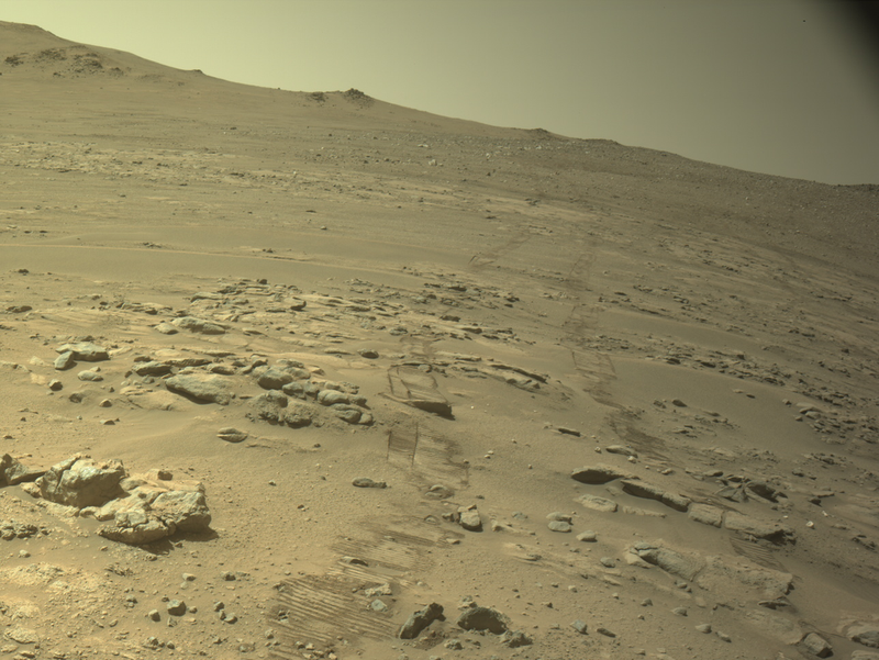
The science payoff from the extra mileage is already showing up. The record-breaking sol took place inside a strip of terrain nicknamed Lac de Charmes on the western rim of Jezero, an area of the crater wall the science team picked specifically because the rocks there are some of the oldest Perseverance will ever see, pieces of crust old enough that their Earthly equivalents have been erased by erosion and plate tectonics. Mars has no plate tectonics, so the equivalent record is still readable on the surface. The rover is heading toward an outcrop named Idubi, where it will look for evidence of ancient hydrothermal systems, the kind of mineral-rich, hot-water environments that on this planet often host the most interesting microbial communities. The earlier leg of the mission already produced one potential biosignature, at a rock called Cheyava Falls in the ancient river delta, and Lac de Charmes is a chance to test whether similar chemistry shows up in a completely different part of the crater. NASA approved Perseverance’s first mission extension this month, a commitment that will carry the rim work through roughly the end of 2028 and, after Lac de Charmes, toward Rainbow Falls, a 328-foot-wide (100-meter-wide) block of ancient crust that was shoved into place by the same impact that created Jezero in the first place. The image that the team released to mark the milestone is a navigation-camera frame from the record sol: a stretch of rocky Martian ground under a dusty sky, with fresh rover tracks curving off into the distance. It is a working picture, the kind of frame the navigation team uses to plot the next day’s drive, not a glamour shot from Mastcam-Z, and that feels right for what is being celebrated. As long as the wheels turn and the software holds up, the number on the dashboard will keep climbing, and the science team will keep pulling rocks out of rocks that have been sitting on the surface of Mars for four billion years. NASA Science blog (12 Oct 2026), NASA Mars 2020 mission page, NASA Photojournal PIA26812 (13 Oct 2026), Sci.News (Oct 2026)
 

October 17, 2026

JAXA’s MMX is finally going to Phobos

Posted by


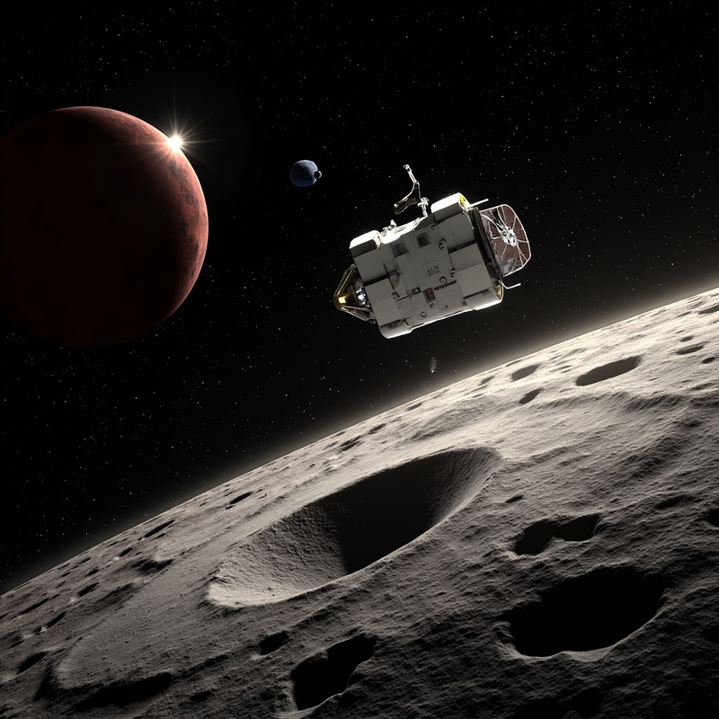
JAXA's MMX spacecraft approaching Phobos — a gray cratered body with the large Stickney crater dominating the foreground, the spacecraft three-quarter view with its high-gain antenna pointed at distant Earth, the red disk of Mars in the background, and the smaller moon Deimos as a tiny point of light nearby.

On Sunday morning Japan time, a 4,000-kilogram spacecraft will leave Tanegashima Space Center on Japan’s new H3 rocket and begin a five-year journey to do something nobody has done before: touch a moon of another planet and bring a piece of it home. The mission is the Martian Moons eXploration probe (MMX), and its destination is Phobos, a 22-kilometer rock that swings around Mars three times a day and is slowly falling inward. A small capsule will land in an Australian desert in 2031 carrying at least ten grams of alien dirt that may finally settle a sixty-year argument about where Phobos came from.


That argument is unusually clean for planetary science. Two possibilities fit the observations, and they point in opposite directions. Either Phobos and its smaller sibling Deimos are captured asteroids — dark, carbon-rich bodies pulled in from the outer main belt — in which case they should resemble primitive outer-belt material. Or they are the wreckage of a giant impact on early Mars, a process analogous to how Earth’s own Moon formed, in which case they should be dry, glass-rich, and chemically indistinguishable from Martian basalt. Existing remote sensing cannot break the tie. Phobos is too small and too dark for Earth-based spectroscopy to read its surface cleanly, and the two theories predict mineralogies that differ in subtle ways. Only a sample under a laboratory bench can decide.

That is what JAXA is sending MMX to do. Approved in February 2020 under project manager Yasuhiro Kawakatsu and shipped to Tanegashima in March 2026, the probe lifts off at 04:41 JST on 20 October 2026, 19:41 UTC on the 19th (ESA, 13 October 2026). The probe is built in three modules: a 1,800-kilogram propulsion section carrying about 1,900 kilograms of bipropellant, a 150-kilogram exploration module, and a 1,050-kilogram return module that will eventually fire its own engine, depart Phobos, and re-enter Earth’s atmosphere. The rocket is the H3-24L, the four-solid-booster variant of Japan’s flagship. The H3 failed its first two flights in 2023, and getting it back to operational status was the engineering prerequisite that made MMX possible at all.

Seven instruments ride on the main spacecraft, and four more sit on a small rover called IDEFIX that will be deployed in early 2029. NASA’s contribution is MEGANE, Japanese for “eyeglasses,” a gamma-ray and neutron spectrometer built at the Johns Hopkins Applied Physics Laboratory that reads elements like hydrogen, which cameras cannot see, to determine how much water-bearing material is present. CNES in France built MIRS, a near-infrared spectrometer for mineral identification. JAXA added a LIDAR, a dust counter to look for a hypothesized faint ring of debris around Mars, and a mass spectrometer for the local ion environment. The IDEFIX rover is a joint CNES-DLR build, weighs 25 kilograms on Earth, and will weigh the equivalent of fifteen grams on Phobos (ESA, 13 October 2026).

The path MMX will fly is itself an engineering problem. Phobos is too small for a true orbit — a satellite around the moon would be perturbed away by Mars within days. Instead, MMX will use a quasi-satellite trajectory, a Mars-centered path that lets the spacecraft stay near the moon for a full Martian year. The geometry is governed by the mass ratio between the two, about 1.7 × 10⁻⁷, which is too small to permit a stable bounded orbit around the moon. The same physics that holds objects at the L1 and L2 Lagrange points lets a spacecraft at the right distance and phase angle drift along with the moon indefinitely.

The sampling system is a second engineering story. JAXA is flying two redundant mechanisms. The first is a coring-and-shovel arm of traditional design. The second, called P-sampler, was developed by Honeybee Robotics and is the descendant of a Planetary Society-funded prototype called PlanetVac. Where most regolith samplers depend on a lander’s weight for a percussive motion, P-sampler fires pulses of nitrogen gas to stir the surface into a vortex, then sucks the cloud into a collection chamber, working whether the lander is upright, tilted, or on one footpad. PlanetVac’s path to Phobos is a parable of compounding: a 2013 lab test, a 2018 flight on Masten’s Xodiac rocket in the Mojave, a 2025 demonstration on Firefly’s Blue Ghost lunar lander, and now inclusion on MMX as a primary sample-acquisition method (Planetary Society, 14 October 2026).

The mission timeline runs five years. MMX will arrive at Mars in August 2027, enter a quasi-satellite orbit around Phobos in September, study the moon for roughly eighteen months, release IDEFIX in early 2029, and land in 2030 to collect the sample. The return module will then push off Phobos, swing past Deimos, and head home. The sample capsule is designed to land in the South Australian outback.

What MMX finds is the test. A captured-asteroid Phobos should have the spectral fingerprints of carbonaceous chondrites, with hydrated silicates and organic compounds. An impact-ejecta Phobos should look like a re-melted piece of Martian crust, dominated by olivine and pyroxene in a glassy matrix. Either answer changes planetary science. The capture scenario would re-open the question of how many small moons are interlopers rather than natives. The impact scenario would mean Mars once had a ring system that briefly rivaled Saturn’s. The samples also carry information no remote observation can read: cosmic-ray exposure age, solar-wind noble gases, the isotopic ratios that fingerprint Martian versus asteroidal origin. ESA project scientist Elliot Sefton-Nash put it simply: samples returned to Earth are “the gift that keeps on giving,” because the same ten grams will be analyzed for decades by instruments not yet invented.

That’s why Japan built this spacecraft, and why a rocket that failed its first two flights is about to carry it off the pad. The question of where Phobos came from has been the cleanest unsolved problem in solar-system science for half a century, and MMX is the cleanest possible test of it. Sunday’s launch opens the clock.


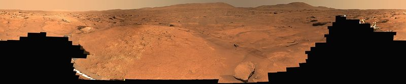
A 360-degree Mastcam-Z panorama of Turquoise Bay in the Margin Unit along the inner edge of Jezero Crater, stitched from 818 natural-color images Perseverance captured between October 5 and 16, 2023, sols 933 through 944 of the mission. The rolling brownish-red Martian terrain stretches to the horizon, with the rover itself visible as a small bright glint near the center of the panorama.


A piece of rock on the inner rim of Jezero Crater was soaked at least three times by very different waters over the course of Martian history, and NASA’s Perseverance rover has now read each of those chemical signatures off the same outcrop. The work, led by Candice Bedford at Purdue University, appears in the journal Communications Earth & Environment and was published online on September 21, 2026 (NASA Mars news, Sep 21 2026; Sci.News coverage). It turns a single strip of terrain along the crater’s former shoreline into one of the more interesting astrobiology sites on the planet, and it quietly resets a long-running debate about how the rocks there formed in the first place.

The location in question is called the Margin Unit, a band of rock that hugs the inner edge of Jezero’s rim where the ancient lake that once filled the crater met dry land. Mission scientists had been puzzling over it since before Perseverance even landed. Orbital instruments had shown strong carbonate signals along that shoreline, and carbonates are the sort of mineral that on Earth usually forms in shallow, life-friendly water, so the natural expectation was that the Margin Unit would turn out to be sedimentary rock, the layered, sandy stuff that is great at trapping microbial remains. Instead, Perseverance’s instruments showed that the band is mostly olivine-rich igneous rock, a coarse-grained material that on Earth typically crystallizes slowly underground from cooling magma. The carbonates are there, but they are not the original rock. They are an overprint, and the new paper unpacks how three separate waters, each with a different temperature and chemistry, left their own overprint on the same parent material over time (Universe Today, Sep 24 2026). That detail matters because the Margin Unit sits inside one of the largest carbonate exposures on Mars, and Jezero itself has been the centerpiece of NASA’s most ambitious astrobiology campaign in decades. If the orbital carbonate signal really does trace a single ancient lake, then the carbonates are essentially a fossil of that lake, and they should record the chemistry of habitable water. If the carbonates instead reflect a much messier history of groundwater, hydrothermal fluids, and lake water acting on the same rock at different times, the carbonates are not a snapshot of habitability, they are a stack of snapshots. Bedford’s team argues it is the latter, and they have the chemistry to show it.

The paper is built on more than 185 rock targets, all measured by SuperCam, the laser-and-spectrometer instrument perched on Perseverance’s mast. SuperCam fires a laser up to 6.5 meters away at a target rock and reads the spectrum of the resulting plasma to determine the rock’s chemistry. Across roughly 265 meters of vertical relief in the Margin Unit, the team at high elevations saw what they expected from a deep, slow-cooled igneous body: coarse olivine crystals with essentially no sign that water had ever reached them. About 265 meters lower, at the elevation where the ancient lake would have lapped against the crater wall, the same parent rock looks transformed. The olivine grains are fractured, and silica has filled the spaces between them. Some of those silica-bearing samples also contain the calcium-sulfate and fluorite veins that mark a third, much hotter stage of alteration (Space.com coverage). The sequence the team proposes runs as follows. Long before any lake existed in Jezero, carbon-dioxide-rich groundwater percolated through cracks in the olivine-rich bedrock. Where that groundwater met the right minerals, it produced carbonate. As the softer host rock around those carbonate-filled fractures eroded away over billions of years, the carbonates were left standing as ridges, which is the texture that first drew orbital attention to the Margin Unit in the first place. Then, in a window that the team cannot date precisely, water that may have been the Jezero paleolake, or a shift in the chemistry of groundwater connected to the lake, washed through the rock again. This second event partly remobilized the early carbonates and dropped silica into the pore spaces, with more silica appearing in rocks that sit below what would have been the old waterline. Finally, a third water event, this one clearly hotter, drove fluids through younger fractures in the eastern Margin Unit and deposited 25-centimeter-thick veins of calcium sulfate and fluorite. Fluorite, in particular, is a fingerprint of hydrothermal activity on Earth, and finding it on Mars is a strong hint that hot water was circulating through volcanic terrain long after the lake was gone.

Bedford has been working with Mars rovers for a decade, and her framing of the result is worth the gravity. “It is very rare that things are as we expect them to be from orbital data,” she said in a NASA press release accompanying the paper, adding that she hopes the work helps reshape how scientists view the history of water in Jezero and across Mars, and ultimately helps reconstruct the changing climate and habitability of early Mars (NASA Mars news). Her co-author Eleni Ravanis, who works on the SuperCam team at the University of Hawaii at Manoa, made a more specific point about what the silica signal is actually telling us: turning olivine into carbonate leaves silica behind, so the more silica you see, the closer the rock sat to the waterline, which makes silica a kind of paleoshoreline marker for a lake that no longer exists. The implication is that the Margin Unit is not just a place where water once flowed, it is a place where water acted multiple times, with each event leaving its own chemical signature stacked on top of the last.

Astrobiologically, that stacking is the most interesting part. On Earth, the reaction between water and olivine can release hydrogen, and there are microbes that can live off that hydrogen. The reaction also leaves behind carbonate and silica, both of which are good at preserving traces of those microbes. So a rock that has been soaked, reheated, and re-soaked in different fluids is not a worse biosignature target than a rock that has only been touched once. It is a record of a longer, more complicated habitability window, and the chemistry preserved inside it is denser. Perseverance has already drilled and cached samples from the Margin Unit, including cores named Pelican Point and Lefroy Bay, and those samples are expected to be among the most prized tubes in the future Mars Sample Return campaign. If any of those cached samples turn out to carry organic material, this paper will be the document that explains why those particular rocks were the right ones to pick up. The image below is a 360-degree Mastcam-Z panorama of Turquoise Bay, a region inside the Margin Unit, captured between October 5 and October 16, 2023, sols 933 through 944 of the mission, and it shows the kind of rolling, weathered terrain that SuperCam has been analyzing ever since (NASA Photojournal PIA26815).


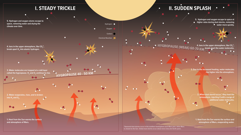
NASA Scientific Visualization Studio infographic showing two side-by-side cross sections of the lower Martian atmosphere, labeled "I. Steady Trickle" and "II. Sudden Splash," comparing normal water loss against the elevated water loss during a global dust storm


Lana Williams, a PhD researcher at Lancaster University, took the stage at the Royal Astronomical Society’s National Astronomy Meeting in Birmingham on July 21 with a result that nobody had set out to find. Her team had been doing a routine comparison: does a solar energetic particle (SEP) event (a pulse of high-energy protons and ions flung out by a solar flare or coronal mass ejection) change the temperature of Mars’ lower atmosphere? Of the five long-duration SEP events the team examined, four showed nothing. The fifth, which arrived while the 2018 planet-encircling dust storm was still expanding, showed a measured warming of roughly 50 °C (about 90 °F) at altitudes of 75 to 125 km. That is a large signal in atmospheric physics, and it appeared in the one event of five where Mars’ surface was already being scoured by a global dust storm (Royal Astronomical Society press release; Phys.org coverage).

The team used two complementary spacecraft that are normally thought of as studying different altitudes. NASA’s Mars Atmosphere and Volatile EvolutioN (MAVEN) orbiter, which has been watching the Sun-Mars interaction since 2014, contributed observations of how the incoming particles deposited their energy in the upper atmosphere. ESA and Roscosmos’ ExoMars Trace Gas Orbiter (TGO), in operation since October 2016, contributed the simultaneous thermal profile of the middle and lower atmosphere. By stacking the two datasets against the Mars Climate Database, the team could see whether observed temperatures diverged from the climatological mean (Sci.News).

Mars is not a protected planet. With no global magnetic field, its upper atmosphere takes the solar wind and SEP events head-on, and the planet’s atmospheric escape rate has been one of the long-running questions in comparative planetology. A radiation-driven temperature pulse in the lower atmosphere is a different kind of signal than the better-studied escape of hydrogen and oxygen from the top of the atmosphere. It means energy deposited above is being communicated downward into the region where dust, clouds, and weather live, and the existing models of that region do not necessarily assume such a connection.

If the pattern holds, the result has practical consequences. Dust storms are the worst time to be operating solar-powered equipment on the surface, and they already coincide with the kind of optical depth that ends rover missions, the 2018 storm being the one that finally silenced Opportunity. Adding a SEP-driven heating pulse on top of an already-stressed atmosphere changes the radiation environment and the upper-tropospheric temperature profile, with consequences for any future crew or uncrewed habitat. The work also offers a partial answer to a question that has been quietly bothering Mars atmospheric scientists: the models did not always match the 2018 TGO temperature record as well as one would like, and a SEP component may explain some of that residual.

Williams and collaborators at the University of Leicester and the Instituto de Astrofísica de Andalucía–CSIC in Granada selected five SEP events spread across the period when MAVEN and TGO were both returning science data. The event selection was the careful part: the team required each SEP to be long-duration, so that any thermal response would have time to propagate, and required both spacecraft to be making compatible observations at the same time. The first four events, occurring in quieter atmospheric conditions, did not produce a statistically meaningful divergence from the Mars Climate Database’s predicted temperature profile. In the team’s own words, “we expected that these highly energetic particles might have some effect on temperatures in Mars’ lower atmosphere, but in four of the five events we studied we found no clear evidence of heating.” The fifth, in June 2018, broke the pattern by a wide margin (Royal Astronomical Society press release; Tech Times).

The June 2018 event is the storm that ended Opportunity’s mission. NASA formally declared the rover’s end in February 2019 after more than a thousand recovery commands went unanswered, and the global dust storm that began on May 30, 2018 grew into a planet-encircling event by mid-June, with optical depths in some regions reaching tau values of 5 to 10, enough to blot out direct sunlight at the surface (2018 Mars global dust storm, Wikipedia; Space.com retrospective). It is also the same storm during which MAVEN’s Neutral Gas and Ion Mass Spectrometer measured water vapor 20 times higher than usual, lifting moisture to altitudes where it could be broken apart by ions and lost to space. That measurement was published in 2020 and is now the standard reference for the role of dust storms in Mars’ long-term water loss (NASA SVS infographic, MAVEN team).

A second-order detail has to be acknowledged. NASA’s MAVEN lost contact with Earth on December 6, 2025, and a February 2026 review board concluded the spacecraft was not recoverable. NASA formally ended the mission in May 2026 (MAVEN, Wikipedia; Reuters, May 2026). The Lancaster study relies on archived MAVEN data, so the analysis itself is not affected by the spacecraft’s loss, but the result arrives at a moment when the only orbiter dedicated to studying the Sun-Mars interaction is no longer in operation. Future SEP-Mars coupling studies will lean even more heavily on TGO and on Mars Reconnaissance Orbiter’s continuing aeronomy observations.

The 50 °C / 90 °F warming at 75 to 125 km altitude is not, on the face of it, what one would expect. SEPs deposit their energy high in the atmosphere, mostly through ionization of CO₂, which is the dominant species on Mars. In a quiet atmosphere, that energy is radiated away or conducted to space faster than it can build a temperature signal in the middle atmosphere. The Lancaster team’s working hypothesis is that the suspended dust changes the radiative budget of the lower and middle atmosphere. Dust absorbs upwelling infrared and re-emits it; it also provides a denser population of ice-coated grain surfaces on which water can condense. The net effect is to keep the middle atmosphere warmer than the climatology would predict, so when an SEP event dumps a pulse of energy from above, the column is already closer to a thermal threshold and the additional heating becomes visible. This is a “two stressors, one signal” pattern that has analogues on Earth in stratospheric ozone chemistry and aerosol-radiation interactions, but the Mars case is cleaner because the two drivers are so well separated in time and altitude (Gizmodo coverage of the talk; Phys.org).

For the engineering side, the result matters because MAVEN and TGO were not designed to look for this signal. MAVEN’s strength is in-situ ion and neutral measurements in the upper atmosphere, with instruments like NGIMS and IUVS. TGO carries NOMAD and ACS for atmospheric spectroscopy, plus a radio-science experiment that uses the spacecraft’s occultation link to derive vertical temperature profiles. Putting the two together for an SEP-dust synergy study is the kind of cross-mission analysis that only became possible once both archives had matured. The lesson for future Mars exploration architecture is the same one that keeps coming back: the value of long-lived orbital assets is realized years after their prime mission ends.

A methodological caveat is worth flagging. The Lancaster team is presenting one matching event out of five. The result is suggestive but it is not yet a population-level claim. The Royal Astronomical Society’s framing, “first study hints,” is doing real work in the press release (Royal Astronomical Society press release). Confirming or refuting the synergy will require a second matching event, and global dust storms that produce them happen roughly once every three to four Mars years, so the next opportunity may not come until late in Solar Cycle 26 or into Cycle 27.

The take-home is that Mars’ lower atmosphere is not a passive target for whatever the Sun and the surface throw at it; it is a coupled system in which a dust-driven radiative perturbation can change the visibility of a solar-driven energetic perturbation. That coupling was not in the models in 2018, and it should be in the next round. The Lancaster team has put a concrete, well-instrumented case on the table and is asking the field to plan for the next match. The answer will come on a Mars year measured in years, not months, and the MAVEN and TGO archives are now the legacy infrastructure on which that answer will be built.


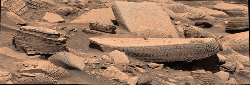
Layered beige Martian rocks at the Jawbone Canyon site in Gale crater, photographed by NASA's Curiosity rover on Sol 4391 (December 12, 2024), showing the stacked wind ripple laminations interpreted as supercritical climbing wind ripple strata.


Somewhere around 3.6 billion years ago, on what was probably an unremarkable afternoon, a sandstorm rolled into Gale crater on Mars. It may have lasted only hours. By the next day, the wind was back to normal and the surface was a sunlit desert again. No one saw it. Nothing else on the planet recorded it. But the storm left a physical imprint, and NASA’s Curiosity rover drove past that imprint on December 12, 2024, on its 4,391st Martian day, and photographed it (NASA Science Photojournal, July 20 2026).

The imprint is now the cover paper of the July 1, 2026 issue of the journal Geology. A team led by Steven Banham of Imperial College London describes millimeter-thick, crinkly laminations inside a rock the rover team nicknamed “Jawbone Canyon,” in the Mirador formation on the lower slopes of Mount Sharp. The structures are supercritical climbing wind ripple strata: a class of wind-deposited layering so rare on Earth that sedimentologists have only documented it in a handful of modern and ancient settings, and never before on another planet (Banham et al. 2026, Geology 54(7):611, DOI 10.1130/G54158.1).

Mars climate science has long had a sandstorm problem. Orbital cameras have shown that dust devils and regional dust storms lift fines off the surface today. Climate models assume that early Mars had a thicker atmosphere capable of moving sand. But the physical evidence for sustained sand-moving winds on ancient Mars has been almost entirely indirect: cross-bedded sandstones that record long-term wind patterns, dune fields that froze into rock, ventifacts worn by saltation.

Those records cannot resolve a single weather event. A climbing wind ripple is the signature of a wind strong enough, lasting long enough, and carrying enough sand that the ripples could not migrate as fast as new sand arrived. The crests piled up on the stoss side instead of sliding down the lee side. Each millimeter-thick lamina is the trace of a burst of sand transport; the climb angle records how fast sediment accumulated relative to how fast the bedform moved. The team measured angles of 10 to 18 degrees, values the paper says can only be produced by storms lasting minutes to hours, not by seasonal winds over thousands of years.

That makes the Jawbone Canyon outcrop the first direct physical evidence of a sandstorm on Mars. The paper’s wording is measured: “These climbing ripple sets occur in a thin succession, which suggests that they record a broader sustained event, such as a sandstorm or gale, lasting several hours or more.” The phrase is doing real work, because the alternative explanations had to be ruled out one by one. The central argument is a negative: ordinary wind regimes cannot deposit climbing ripples of these thicknesses at these angles, so whatever made them had to be stronger than everyday wind.

A secondary argument reaches further. Banham notes in the paper and in press interviews that the modern Martian atmosphere, at roughly 6 millibars of mean surface pressure, is too thin to drive saltation at the scale required to build these structures (Astrobiology.com, April 4 2026). The deposits imply that the atmosphere three and a half billion years ago was denser than today’s. The exact density is not pinned down, but the qualitative conclusion is clear: the air on early Mars was heavy enough to push sand in ways the present-day air cannot.

The find was not part of any planned observation. Curiosity’s science team operates in shifts, and one of the standing tasks is to scan the black-and-white navigation panoramas taken at the end of each drive for anything anomalous. Banham and his collaborators, including Linda Kah of the University of Tennessee, Joel Davis of Imperial College London, Sanjeev Gupta, Gerhard Paar, and several JPL-Caltech sedimentologists and mission scientists, noticed unusual textures in those panoramas as the rover approached the Mirador formation. They targeted the rocks with the higher-resolution Mastcam, and at full resolution the laminations resolved into the climbing ripple patterns.

Banham described the find as serendipitous: “We weren’t really looking for these deposits, and then lo and behold, we drove around the corner and found them. We were lucky that we had just the right people on shift that recognized them.” The rock itself is modest in size, roughly a meter wide and 20 centimeters high, with six discrete packages of ripple layers stacked through its thickness. The laminae dip toward the north, which means the wind that built them came from the south. Similar climbing ripples were later identified at a nearby site the team named Dry Lake, and the paper argues that the deposits formed near the margin of a larger dune field or in a wind-scoured depression where airflow patterns concentrated sand accumulation.

The discovery is also a vindication of the Mastcam team’s instinct to keep taking high-resolution follow-up imagery of “unusual” textures. Climbing ripples this small could have been mistaken for noise in lower-resolution data, or simply dismissed as weathered outcrop. The fact that a thin succession of six packages survived in one place for over three billion years, exposed at the surface for the rover to roll up to, is its own piece of good fortune.

The terminology is precise. In sedimentology, ripples are small bedforms, typically a few centimeters tall and tens of centimeters in wavelength, that form when wind or water flows over a bed of loose sand and organizes it into regular undulations. In a normal subcritical regime, sand grains saltate up the windward (stoss) face and avalanche down the leeward (lee) face, and the ripple migrates downwind without growing vertically. In a supercritical regime, the wind is strong enough and the sand supply is high enough that grains accumulate faster on the stoss face than they can slide off the lee face, so the ripple climbs. The climb angle is set by the ratio of vertical accumulation to horizontal migration; a 10-degree angle corresponds to roughly six times as much vertical deposition as horizontal migration.

Climbing ripples have been documented in a small number of terrestrial settings: deep-sea turbidity currents, certain wind-blown dune margins, and a few fluvial flood deposits. They are rare because the conditions that produce them are themselves unusual. On Mars, no one had ever identified them, in part because orbital images cannot resolve millimeter-scale laminae and in part because no previous rover had driven through sedimentary terrain with both the imaging resolution and the science team bandwidth to spot them.

The Banham paper lays out the diagnostic criteria: millimeter-scale lamina thickness, climb angles between 10 and 18 degrees, preserved stoss-side grainflow cross-stratification, and lateral continuity across the outcrop face. All four appear at Jawbone Canyon. The team estimates that a single 50-millimeter-thick layer could have formed in 6 to 20 minutes under storm conditions; the full succession of six packages therefore records on the order of an hour or two of sustained sand transport (Daily Galaxy, July 17 2026).

Curiosity has been on Mars for more than thirteen years. In that time it has found evidence of ancient lakes, rivers, groundwater, organic molecules, and a past climate that was at least intermittently habitable. What it had not found, until now, is direct evidence of an ancient sandstorm. The Jawbone Canyon outcrop fills that gap with a single rock roughly the size of a kitchen table.

The immediate payoff is a new constraint on early Mars atmospheric density: the air had to be thick enough to drive saltation at storm intensities. The longer-term payoff is a search template. Banham has said the next thing he wants the team to find is raindrop impact marks, craters in fine sediment left by rain, which would settle a separate debate about whether early Mars ever saw liquid rain rather than only snow and surface runoff. “It would be magic if we found those,” he said. The climbing ripples are not the last stop on Curiosity’s geology to-do list. They are evidence that the rover is still, after 4,391 sols, finding things on Mars that no one had asked it to look for.


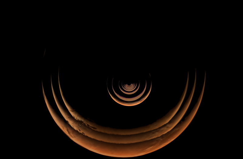
A composite of orange Mars crescents grows outward against black space as Psyche approaches the planet.


A gravity assist is usually described as celestial bookkeeping: a spacecraft borrows a little momentum from a planet and leaves on a better trajectory. NASA’s Psyche mission did that at Mars on May 15, 2026, but its science teams treated the encounter as much more than a navigation event. They pointed the spacecraft’s instruments at a world whose properties are already well measured, then asked whether the hardware returned the answers it should.

The spacecraft passed 2,864 miles (4,609 kilometers) above the Martian surface. Its cameras watched a thin crescent grow into a detailed globe. Its magnetometer crossed Mars’ bow shock. Its neutron detector registered a rise in particles near closest approach. The resulting data, released in July with a time-lapse video, made Mars a dress rehearsal for a far less familiar target: the metal-rich asteroid Psyche, which the spacecraft is due to reach in 2029, according to the NASA Science flyby report.

Space instruments spend years being designed, calibrated, launched, and monitored, but cruise provides few chances to test them against a large planetary body. Stars can check camera pointing. The solar wind gives a magnetometer a continuous signal. Neither reproduces the rapid changes, bright surfaces, stray light, and particle environment of a close planetary pass.

Mars offered a rare controlled comparison. Orbiters and rovers have observed its surface, atmosphere, and magnetic environment for decades. If Psyche’s instruments measured something wildly inconsistent with that record, engineers would have time to diagnose the discrepancy before asteroid arrival. Agreement is useful too: it confirms that the instrument, onboard electronics, ground pipeline, and scientific interpretation work together after nearly three years in space.

That last point matters because Psyche’s destination is difficult to interpret. The asteroid is often described as metal-rich, but the mission exists because remote observations cannot settle how much metal it contains, how it formed, or whether it preserves material from the interior of an early planet-building body. The spacecraft carries three dedicated science instruments: a multispectral imager, a magnetometer, and a gamma-ray and neutron spectrometer. It will also use radio tracking to map the asteroid’s gravity, as described in NASA’s Psyche mission overview. Mars let the instruments work on the same known target within hours.

Psyche launched in 2023 on a long solar-electric cruise toward the main asteroid belt. Mars was part of the route from the start. Before the encounter, NASA expected the spacecraft to pass about 2,800 miles above the surface at roughly 12,333 mph (19,848 kph). The planet’s gravity would increase the craft’s heliocentric speed and tilt its path toward the asteroid, according to the May 8 NASA mission brief.

The images began well before closest approach. Starting in early May, Psyche’s pair of identical multispectral cameras photographed Mars at a high phase angle, so the sunlit portion looked like a slender crescent. The sequence from May 2 through May 15 shows that crescent expanding as the distance closed. NASA assembled those frames into the growing-crescent composite used with this post.

Near Mars, the cameras resolved the south polar ice cap, wind-marked craters, and Huygens, a large double-ring crater. The team also detected Phobos and Deimos from far away. That was useful practice for a later search for small moons around asteroid Psyche. More quietly, the imaging team tested sensitivity to scattered light and began comparing its pictures with data from existing Mars missions. A camera can produce a sharp image and still mismeasure brightness or color; cross-calibration helps expose that kind of error.

The particle spectrometer faced a different test. It is intended to infer surface composition at the asteroid by measuring gamma rays and neutrons generated after cosmic rays strike the material. At Mars, the 4,609-kilometer altitude was too high for the detector to pick up gamma rays from the surface. The team did expect escaping neutrons, and the instrument recorded a count-rate increase close to the predicted level near closest approach.

The magnetometer had spent cruise measuring the solar wind and occasional coronal mass ejections. Mars provided its first magnetic signature from a celestial body. As Psyche entered the bow-shock region, where the solar wind encounters the obstacle formed by Mars and its induced magnetic environment, the instrument saw a strong increase. The flyby therefore exercised the detector through a rapidly changing field rather than the relatively steady background of interplanetary space.

Navigation also delivered what the science plan needed. The flyby put the spacecraft directly on its outbound course, and the mission expects to resume sustained solar-electric thrusting later in 2026. Arrival remains planned for the summer of 2029.

A gravity assist works because the planet and spacecraft exchange momentum while both orbit the Sun. In a Mars-centered frame, the spacecraft falls in, curves around the planet, and departs with approximately the same hyperbolic excess speed it had on arrival. In the Sun-centered frame, however, the velocity vector has rotated. Adding Mars’ orbital velocity before and after that rotation changes the spacecraft’s speed and direction around the Sun. Mars loses or gains an immeasurably small amount of orbital momentum in return.

The maneuver gave Psyche both energy and geometry that electric propulsion alone would have taken longer to supply. Its Hall-effect thrusters expel ionized xenon and produce low thrust for long periods. That system is efficient, but a planetary flyby can rotate the trajectory quickly without consuming propellant. Precision is unforgiving: a small arrival error changes the bending angle and therefore the outbound path. The close approach matching the planned corridor shows the navigation chain worked from orbit determination through correction maneuvers.

The instrument tests relied on three different physical signals. For imaging, filters divide reflected light into wavelength bands. Variations among bands can distinguish surface materials and reveal how illumination geometry affects the measurement. Mars supplied bright terrain, dark terrain, haze, ice, and a changing phase angle in one encounter.

For the neutron measurement, energetic cosmic rays strike atomic nuclei in the upper surface and create cascades of secondary particles. Some neutrons escape. Their energy distribution depends partly on which elements slowed or absorbed them. Hydrogen, for example, is particularly effective at reducing neutron energy. Gamma rays occur at characteristic energies associated with specific nuclei, but signal strength falls rapidly with distance; Psyche’s altitude explains why neutrons were detectable while Martian gamma rays were not.

Mars has no strong global dipole field like Earth’s. The solar wind interacts with its upper atmosphere and localized crustal magnetism, producing a bow shock upstream of the planet. Crossing that boundary gave the magnetometer an abrupt, recognizable change against which its timing and response could be checked. At asteroid Psyche, any remanent field would bear on whether its material once cooled within a magnetized parent body.

The Mars flyby did not answer the central question about asteroid Psyche. It reduced the risk that, three years from now, the mission will reach its target with a hidden calibration problem or an analysis pipeline that has never handled a fast-changing planetary data set.

That is the practical value of using a familiar world as a test object. The cameras returned surface detail and distant moon detections. The neutron detector saw the expected count increase. The magnetometer identified the bow shock. Each result connects directly to a job the instrument must perform at the asteroid, where there will be no fleet of orbiters and rovers providing an easy reference.

The spacecraft now has its outbound trajectory and a set of measurements the teams can keep analyzing while electric propulsion carries it toward the main belt. When asteroid operations begin in 2029, the first observations will still contain surprises. The basic behavior of the instruments should not be one of them.