OrbitalHub

Where curiosity reaches escape velocity.

Domain is for sale. $50,000,000.00 USD. Direct any inquiries to contact@orbitalhub.com.

Archive for the Spacecraft Design category


A render of Reflect Orbital's Eärendil-1 sunlight-reflection satellite with its thin-film reflector deployed.


On July 9, 2026, the Federal Communications Commission granted a license to a small California company called Reflect Orbital to launch a satellite the size of a dining table, fold out an 18-meter sheet of mirrored Mylar 625 km above the ground, and aim a moving five-kilometer-wide spot of sunlight at whatever patch of Earth it wants to illuminate. The license covers a single satellite, Eärendil-1, and a single demonstration pass. The wider plan is as many as 50,000 such spacecraft by 2035.

The FCC’s order authorized radio spectrum for the spacecraft and the data link that will run the test. It did not authorize the act of bouncing sunlight at people, because that act is not a communications function and the agency does not regulate light. That distinction is the hinge on which the entire controversy swings, and it is why the American Astronomical Society called itself “dismayed” within hours of the announcement (The Debrief, July 16, 2026).

Astronomy is one of the few sciences whose primary signal is the absence of unwanted light. Ground-based optical telescopes depend on a sky that is, in their exposure windows, mostly dark. The Vera C. Rubin Observatory in Chile is currently running the largest astronomical survey ever attempted, stacking thousands of wide-field exposures from a 3.2-gigapixel camera over ten years. Every photon that does not come from a star, galaxy, or asteroid is a contaminant. Each Starlink train and imaging constellation has already cost the field time and money, and astronomers have spent the past five years learning how to subtract that signal from their data.

Eärendil-1 is a different kind of contaminant. It is not a point source streaking through a single exposure. It is a deliberate, modulated light source that the operator can point at any ground patch within range. Tony Tyson, the chief scientist of the Vera C. Rubin Observatory, told a National Academies meeting on June 4 that he considered the plan “even crazier” than the broadband constellations, because the thin-film reflectors would scatter sunlight rather than aim it precisely. “Imagine the sky full of moons,” he said (SpaceNews, July 10, 2026).

The European Southern Observatory, which operates some of the largest optical telescopes on Earth in Chile’s Atacama Desert, weighed in on July 1 with a calculation: a full 50,000-satellite Reflect Orbital constellation would multiply the background sky brightness at its facilities by a factor of three to four. Betty Kioko, an institutional affairs officer at the observatory, called the technology “an existential threat” to optical astronomy. Reflect Orbital’s FCC application drew nearly 1,900 public comments, almost all of them critical, before the agency ruled.

Reflect Orbital is based in Hawthorne, California, a few miles from SpaceX headquarters. The company calls itself “the sunlight company.” Its premise is that the Earth’s day-night terminator is, from a commercial standpoint, a wasted hour at the start of every morning and another at the end of every evening, and that an orbital mirror could redirect a small slice of sunlight onto a solar farm or work site during those hours. The chief executive, Ben Nowack, has said the satellites could extend the operating hours of terrestrial solar plants before sunrise and after sunset.

The FCC order, issued in the standard format used for experimental satellite licenses, gives the company permission to use the radio frequencies needed to control the spacecraft and telemeter its health data back to the ground. It does not, as the agency itself noted, authorize the optical payload. The 142-kilogram Eärendil-1 will carry a thin-film square reflector 18 meters on a side, made of aluminized Mylar, folded into the satellite’s body for launch and unfurled once the spacecraft reaches an altitude of 600 to 650 kilometers in a near-polar orbit inclined at 88 degrees. Reflect Orbital has said the satellite will ride to orbit on a SpaceX rideshare mission later in 2026.

The operational concept is to keep the reflector pointed at the Sun while continuously tilting its face so that the reflected beam sweeps across the dark side of the Earth below. A single satellite at 625 km can hold a five-kilometer-wide spot on the ground for several minutes at a time. With dozens or hundreds of satellites spaced around the orbit, the spot could be passed from one to the next and held for hours. The company has also said the light produced is “not bright enough to start fires or harm eyes, even when viewed through a telescope, and cannot be concentrated past maximum natural sunlight irradiance,” and that it will maintain exclusion zones around astronomical observatories and turn the beam off instantly on command.

The American Astronomical Society’s statement, released the same day as the FCC decision, was direct. It warned of damage to sensitive research instruments and flash-blinding risks to pilots and drivers, and noted that the company’s own FCC filings had included language about the possibility of permanent eye damage to anyone looking through a mid-sized telescope at the wrong moment. The society cited research suggesting that a full constellation could double or triple nighttime sky brightness even at remote observatories through atmospheric scattering of the reflected light.

The FCC’s response to those arguments was procedural. The agency’s order concluded that “concerns about Eärendil-1’s impacts on optical astronomy fall outside our review and authorization of the space station and are not a basis for denial of or additional conditions on Reflect Orbital’s operations.” It added that the company had committed to working with NASA and the National Science Foundation to address astronomical concerns. The agency framed its role narrowly: it regulates spectrum, not photons, and concluded that making spectrum available for new space activities serves the public interest.

A flat reflector in orbit cannot turn night into day, but it can shift the natural terminator. The Earth rotates once every 23 hours and 56 minutes, so any point on the equator spends roughly twelve hours in sunlight and twelve in darkness. A satellite in a sun-synchronous orbit at 625 km circles the planet about fifteen times a day, and on roughly half of those passes the spacecraft is on the lit side. The geometry that matters is the specular reflection angle: the mirror must be oriented so its normal vector bisects the angle between the incoming Sun and the outgoing ground spot, and that angle changes continuously as the satellite moves along its orbit.

The reflector itself is the simplest part. Aluminized Mylar at this scale has a mass per unit area of roughly 50 grams per square meter [unverified], so an 18-by-18-meter sheet weighs on the order of 16 kilograms. The hard engineering problems are attitude control and pointing stability. To hold a five-kilometer spot from 625 km up, the angle of the mirror must be controlled to within roughly 0.1 degrees [unverified]. Any vibration, thermal distortion, or gravitational sag in the unfurled sheet will smear the spot.

The scale of the proposed constellation is what worries astronomers most. Fifty thousand satellites at 625 km would put roughly one reflector every 100 kilometers along every orbit. Even with each satellite dark for half its orbit, the cumulative effect on the night sky would be a steady, moving pattern of bright objects that no terrestrial observatory could subtract out with software. The light is not radio interference, which can be filtered; it is broadband visible light in the same band the telescopes are trying to measure.

The FCC has approved a single test satellite, not a constellation. Reflect Orbital has until the end of 2026 to fly Eärendil-1, deploy its reflector, and demonstrate that the beam can be aimed precisely enough to stay inside the intended target zone. If the demonstration succeeds, the company will return to the FCC and likely to other agencies for the spectrum, orbital debris, and launch approvals needed for a full constellation. If it fails, the controversy loses its anchor. In the meantime, the American Astronomical Society, the European Southern Observatory, and the Vera C. Rubin Observatory argue that the test alone has already shifted the burden of proof, because the same engineering that lets one satellite hold a beam on a five-kilometer spot is the engineering that, multiplied by fifty thousand, lights up the night sky over the world’s best observatories.
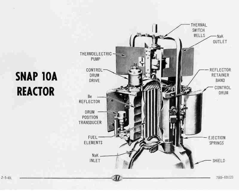


Labeled cutaway diagram of the SNAP-10A reactor, showing the Be reflector, fuel elements, control drum drive, thermoelectric pump, NaK inlet and outlet, and ejection springs, dated 2-5-65


Antares Nuclear, a three-year-old startup in Torrance, California, walked away from a September 14, 2026 award ceremony with what it calls the largest U.S. Department of War contract ever signed specifically for nuclear power in space: $161 million to design, ground-test, and eventually fly a fission reactor on a spacecraft. The Office of the Assistant Secretary of the Air Force for Space Acquisition and Integration structured the Strategic Breakthrough award around two related efforts, a ground demonstration of a reactor called R1-S followed by integration work on an electricity-producing variant called Mark-1 that Antares plans to begin testing in 2027. The company has not yet named a target launch date for R1-S or which mission it would eventually support, but the contract is the clearest signal yet that the U.S. government intends to put a fission reactor in orbit in this decade rather than the next (Defence Blog, September 14, 2026).

The strategic logic is straightforward, and it has very little to do with sending astronauts to Mars. Most satellites today run on solar panels paired with batteries sized for eclipse periods, which sets a hard ceiling on how much power is available onboard and how aggressively a spacecraft can maneuver without draining its reserves. A compact fission reactor gives a satellite continuous high-output power instead of the day-night cycle that solar arrays impose, supporting heavier onboard computers, sustained orbital maneuvers, and payloads such as directed-energy systems or electronic-warfare gear that today’s power budget cannot accommodate at all. Jordan Bramble, Antares’ chief executive and co-founder, framed the award the same way his investors do: “Fission will unlock strategic capabilities that are impossible today.” The Department of War’s appetite for those capabilities is not new, but the budget to actually build toward them has historically been small, scattered across NASA and Defense programs, and constrained by a decades-long absence of any American nuclear reactor actually running in space (Defence Blog, September 14, 2026).

The Antares award is the latest milestone in a sequence that began quietly six years before the contract was signed. On June 4, 2026, the company’s Mark-0 demonstrator reactor completed what is technically known as a zero-power fueled criticality at Idaho National Laboratory’s Reactor and Critical Experiment (RACE) facility, the moment at which a nuclear fission chain reaction becomes self-sustaining. The test, conducted under Department of Energy authorization and with nuclear fuel maker BWX Technologies fabricating the fuel, made Antares the first private company to bring an advanced reactor to criticality under the DOE’s Reactor Pilot Program. It was also the first novel reactor design to achieve criticality at the Idaho site in more than fifty years, according to INL Laboratory Director John Wagner, who emphasized that the Mark-0 test produced essentially no measurable thermal output: proof that the physics worked, not proof that the system could yet generate electricity (Power Magazine, June 2026; U.S. Department of Energy, June 4, 2026).

That single June milestone unlocked everything that followed. Data from the Mark-0 test is being shared with the Department of War’s Project Pele, a long-running program to build a transportable microreactor for forward military bases, and Antares is also a supplier under the U.S. Army’s separate Janus Program, which is installing microreactors at installations including Fort Benning, Georgia. The Space Force award is the third major customer the company has signed, after the Army and the Air Force itself, and Antares says it now holds agreements with NASA and the Defense Innovation Unit as well. Private capital has followed the same trajectory: the company closed a $96 million Series B round in December 2025, raising its total private funding above $600 million by mid-2026 (Defence Blog, September 14, 2026; Power Magazine, June 2026).

The policy backdrop is two documents rather than one. Executive Order 14369, signed in late 2025 and titled “Ensuring American Space Superiority,” directed the federal government to “deploy nuclear reactors on the Moon and in orbit, including a lunar surface reactor ready for launch by 2030” (Executive Order 14369, The American Presidency Project). The implementation memo, National Security and Technology Memorandum-3 (NSTM-3), issued on April 14, 2026, gave NASA and the Department of War thirty days to start parallel reactor competitions: a mid-power fission surface power (FSP) system targeted for the Moon by 2030, and a separate space-based reactor to support nuclear electric propulsion. The Antares award sits inside the second of those two tracks, where the schedule is even tighter: NSTM-3 calls for an American reactor in orbit as early as 2028 (SpaceNews, April 2026).

The hardware Antares is building toward looks much more like a 1965 satellite than a 2026 data center. The R1 microreactor, the commercial product the company’s ground-test reactors are iterating toward, uses tri-structural isotropic (TRISO) fuel, particles of high-assay low-enriched uranium (HALEU) coated in layers of carbon and ceramic, embedded in a prismatic graphite core. Passive sodium heat pipes carry heat from the core to a fin-and-tube primary heat exchanger, and a recuperated nitrogen-closed Brayton cycle converts that heat into electricity at outputs between 100 kilowatts and 1 megawatt depending on configuration. The R1 is rated to operate for six or more years between refueling and is designed to run without a connection to the commercial grid, exactly the operating envelope a spacecraft needs (Power Magazine, June 2026). The conceptual lineage runs straight back to SNAP-10A, the only fission reactor the United States has ever placed in orbit, which launched on April 3, 1965 aboard an Atlas-Agena D from Vandenberg and ran for forty-three days before a non-nuclear voltage regulator failed in its thermoelectric pump. The SNAP-10A core used a similar arrangement of uranium fuel elements, a beryllium reflector, sodium-potassium (NaK) coolant loops, and control drums rotated by an electric drive to manage reactivity (Wikipedia, SNAP-10A).

The diagram above, a 1965 U.S. Department of Energy drawing of the SNAP-10A core, illustrates the conceptual continuity. The beryllium reflector wraps the fuel elements and bounces neutrons back into the chain reaction; the control drums rotate to absorb neutrons and throttle reactor power; the NaK loops carry heat from the core to a thermoelectric pump that converts it directly into electricity without moving parts. Antares has replaced the thermoelectric pump with a closed Brayton cycle and swapped the SNAP-era fuel for HALEU TRISO, but the operating principle, a compact, passively cooled, six-year core with no moving coolant pumps, has not changed (Wikimedia Commons, File:SNAP-10A Reactor.jpg).

What has changed is the supply chain. The 1965 program drew on a single nuclear vendor (Atomics International, a division of North American Aviation) and a single satellite integrator; the 2026 program has at least three parallel microreactor vendors (Antares, plus the BWXT-led Project Pele team and at least one other Army Janus participant), HALEU production being stood up at multiple Department of Energy sites, and TRISO fuel fabrication running commercially at BWX Technologies since October 2025. If Antares meets its schedule, the United States will close a sixty-year gap between SNAP-10A and the next American fission reactor in orbit, and the Mark-1 testing campaign starting in 2027 will tell the industry whether the next one after that flies on a lunar lander or a Space Force satellite.


September 22, 2026

A six-band eye for fire

Posted by


The Quickbeam six-channel infrared instrument onboard FireSat. Credit: Muon Space.


At 03:12 UTC on July 7, 2026, a Falcon 9 lifted off from Vandenberg Space Force Base carrying the heaviest single rideshare payload SpaceX had ever dispatched from California: SpaceX’s Transporter-17 mission. Buried among dozens of small satellites were three boxy 100-kilogram buses built by Muon Space, each carrying an instrument the company calls Quickbeam, a six-channel multispectral infrared imager built for one job: spotting wildfires smaller than a suburban kitchen before they become the next headline (SpaceNews, July 2026).

Two weeks earlier, the same instrument on the FireSat Protoflight demonstrator had imaged a small roadside fire northwest of Medford, Oregon, on June 23, 2025. The fire was missed by every other orbital sensor. By the time ground crews arrived, the flames had burned 0.4 hectares. The Protoflight data, published by the Earth Fire Alliance (EFA) on July 23, 2025, made a quiet case for the constellation now commissioning in low Earth orbit: a new generation of spacecraft designed not to study weather or map land cover, but to catch the first watt of heat a forest fire gives off.

Wildfire managers call the first hour after ignition the golden hour. If a fire is suppressed within sixty minutes of ignition, the cost of attack falls by an order of magnitude; if not, the same fire becomes the kind of runaway that closes highways, evacuates towns, and sends smoke across continents (CAL FIRE briefing, October 2025). The problem is that almost every existing satellite fire product was built for something else. MODIS on Terra and Aqua, the workhorse of orbital fire detection for twenty-five years, returns a pixel every ~1 km. VIIRS on Suomi-NPP and JPSS improves that to 375 m. Both see fires only after they are big enough to saturate the detector, and both push alerts in hours, not minutes, because the data lands in a research processing pipeline rather than a dispatch queue.

What fire agencies wanted was a sensor with three properties that the older instruments could not deliver together: spatial resolution sharp enough to resolve a single-campfire ignition, thermal sensitivity high enough to read temperatures below 600 K without saturating, and a latency path short enough to put an alert into a dispatcher’s screen before the wind changes. Quickbeam is the first instrument designed to satisfy all three (Earth Fire Alliance, program overview, 2025).

Quickbeam is a six-channel multispectral imager spanning short-wave infrared (SWIR), mid-wave infrared (MWIR), and long-wave infrared (LWIR). Three of the channels sit in the SWIR at 1.0–2.5 µm, where they map vegetation moisture and burn scars and pick up reflected sunlight on daylight passes. A single MWIR channel covers 3.0–5.0 µm, the fire-detection sweet spot: hot surfaces near 800 K peak here, and atmospheric transmission is high enough that the band survives most smoke columns. The remaining two channels work the LWIR at 8.0–12.5 µm, useful for background temperature, cloud masks, and the dual-use atmospheric work the U.S. Space Force funded as part of the same instrument (Muon Space product brief, 2025).

The 5 × 5 meter ground sample distance per pixel is roughly forty times finer than what VIIRS delivers in its active-fire band. Each satellite flies in a sun-synchronous orbit at ~600 km altitude and images a 1,500 km swath on every pass. With three satellites phasing that orbit, the constellation returns to any fire-prone region at least twice a day today, with a target of one global revisit per hour by 2029 once the full 50-satellite constellation is in place (Earth Fire Alliance roadmap, 2026).

The hardware underneath the optics matters as much as the optics themselves. FireSat rides on Muon’s Condor-M bus, a 100-kg-class small satellite built around what the company calls a CarefulCOTS approach: every commercial part is selected by analysis for radiation, thermal, vacuum, and shock resilience, then qualified per GSFC-STD-7000 or SMC-S-016 with universal derating per NASA EEE-INST-002 (Muon Space, Condor-M spec sheet, 2025).

The numbers tell the rest of the story. The bus delivers 500 W of peak payload power and 200 W orbit-average, supports 30 Gbps payload data interfaces, and dumps 5 TB per day through its RF downlink (50 TB per day if the customer buys the optical comms option). Pointing knowledge is 5 arcseconds 1σ, control is 15 arcseconds 1σ — fine enough that a 5 m pixel stays a 5 m pixel after stacking. Onboard Δv of 3 km/s lets the constellation maintain its precise spacing without waiting for atmospheric drag to do the work over months.

CarefulCOTS, rather than full radiation hardening, is what lets the satellite cost what it costs. A traditional aerospace IR imager of similar capability can run into the hundreds of millions per copy. FireSat is built to a price point closer to a commercial imaging smallsat, which is the only way a 50-satellite constellation makes sense.

Latency is the part most coverage misses. A fire detection that travels satellite → ground station → processing center → alert API is still thirty minutes old by the time it reaches a dispatcher. FireSat runs a Google Research convolutional neural network directly on the satellite’s edge inference chip, assigning a probability score to every 5 × 5 m tile during the same orbital pass that collected the imagery. Alerts with confidence above 85% are pushed over optical inter-satellite links and dispatched directly into CAL FIRE, US Forest Service, and partner-agency APIs within five minutes of acquisition (Earth Fire Alliance technical brief, 2026).

This is a substantial change in how Earth-observation data flows. The traditional pipeline treats satellites as data factories whose product is then mined by analysts. FireSat treats the satellite as a sensor that produces decisions. The downstream user receives an alert keyed to a confidence score, not a raw image. Below threshold, no alert fires; above, the alert is geo-referenced and time-stamped in the same message.

The three satellites launched on Transporter-17 are now in a three-month commissioning and calibration period, with first operational data expected in October 2026. CAL FIRE, the Colorado Division of Fire Prevention and Control, and agencies in Texas, Oregon, the Amazon, Portugal, Australia, and three African countries are signed up as early adopters. The full constellation target is fifty-plus satellites by 2030, with a goal of a twenty-minute global revisit and a nine-minute revisit for the most fire-prone corridors.

What FireSat is really testing is whether a single-purpose constellation, designed around one metric (median time from ignition to alert), can outperform decades of general-purpose Earth-observation infrastructure. The Protoflight demonstration, the Medford fire, the Oregon roadside ignition nobody else saw: these are the early evidence. If the operational constellation hits its five-minute latency goal at 5 m resolution, the cost-benefit math on wildfire suppression shifts in a way that no amount of MODIS data ever could.

FireSat is a reminder that “satellite for X” can mean something other than “satellite that happens to be useful for X.” Every previous fire-detection system inherited its design from weather, land-imaging, or atmospheric-chemistry missions. Quickbeam was built from a detector layout upward to optimize for the MWIR fire peak, smoke penetration, and edge inference. The constellation is sized not to map the planet but to return to a wildfire fast enough that suppression still works. If it hits its numbers, the next decade of wildfire management will look less like remote sensing and more like an alert service, and the first hour of a fire will start to look very different from the last twenty years.


A boxy communications satellite carrying flat panel antennas and solar arrays flies above a cloud-covered Earth.


The launch looked ordinary. On July 16, 2026, at 1:32 p.m. Pacific, a Falcon 9 lifted off from Space Launch Complex 4E at Vandenberg Space Force Base carrying 21 identical flat-panel satellites. The first stage — booster B1103 on its fourth flight — flipped, glided back, and set down on the drone ship Of Course I Still Love You about 8.5 minutes later, logging SpaceX’s 639th successful booster recovery. Routine, until you remember that for nine months before that afternoon, no Tranche 1 satellite of any kind had flown.

The 21 satellites, built by York Space Systems, were the third batch of the U.S. Space Development Agency’s Tranche 1 Transport Layer. They joined 42 others already on orbit. Together those 63 spacecraft form the spine of a network the Pentagon does not quite have a clean phrase for: an internet, of sorts, designed for warfighters, running roughly 1,000 kilometers up in near-polar shells that pass over the equator twice an orbit. By the time the constellation reaches its full Tranche 1 size of 126 satellites, expected by mid-2027, the network will be the largest dedicated military LEO relay ever deployed.

For decades, tactical communications for U.S. and allied forces have run through a handful of heavy, expensive, geostationary satellites. The Advanced Extremely High Frequency (AEHF) constellation carries strategic command traffic in protected, anti-jam channels at $1.8 billion per spacecraft. The Wideband Global SATCOM (WGS) system pipes bulk data to aircraft and ships. Both architectures are excellent when they work. They also depend on a few high-value nodes, parked at fixed slots 36,000 km up, that an adversary can identify, jam, or try to maneuver-kill with a direct-ascent antisatellite weapon.

The SDA’s counter-move borrows a page from commercial internet engineering. Distribute the network across hundreds of small, cheap, replaceable nodes in low orbit, route traffic around any node that gets cut, and refresh the constellation every five years. Multiply the count, distribute the risk, accept a per-satellite ceiling that buys commodity parts rather than bespoke gold boxes. The trade-off is bandwidth per node — geostationary birds carry more — but for tactical purposes where latency and resilience matter more than peak throughput, the math works out differently. The Department of Defense has projected the broader Proliferated Warfighter Space Architecture at roughly $35 billion through fiscal 2029, with about $11 billion already obligated since 2020 (SDA, 2026; GAO-26-107085).

The SDA itself is barely seven years old. Established inside DoD in 2019 to break up a slow, monolithic acquisition culture, the agency set out to demonstrate that a small office in the Pentagon could buy satellites the way a startup buys servers: in tranches, every two years, with each tranche a deliberate step up in capability. Tranche 0, the experimental precursor, flew 28 small satellites between 2023 and 2024 built by York and Lockheed Martin. Those birds proved that optical crosslinks could pass data in low orbit, but a Government Accountability Office report (GAO-26-107085, January 28, 2026) concluded that Tranche 0 never demonstrated an integrated “sensor-to-shooter” loop — partly because the planned capstone demo was reduced after on-orbit calibration ran long.

Still, by the time GAO went to print, the agency had already committed about $9.9 billion in Tranche 1 and Tranche 2 contracts with Lockheed Martin, Northrop Grumman, York, L3Harris, and Sierra Space — roughly fifteen times the Tranche 0 budget of $657 million — before Tranche 0 had fully proven its architecture end-to-end. That decision became the cornerstone of GAO’s headline finding: the risk to delivering missile warning and tracking in Tranche 1 is high.

The first operational Tranche 1 batch, T1TL-A, launched September 10, 2025 with 21 York satellites. T1TL-B followed October 15, 2025 with 21 Lockheed-built satellites. Then the agency paused. Nine months of software fixes, hardware rework, and propulsion diagnostics: a stuck-key scenario in the xenon-feed valve cycling, intermittent glitches in the cryptographic unit, and a series of attitude-control loop instabilities that did not show up on the ground. T1TL-E on July 16 was the resumption, not a clean start. By that afternoon, York had confirmed telemetry from all 21 new spacecraft within five hours of separation; engineers were still working through enabling the optical mesh.

What makes this constellation unusual is the radio underneath it. The rest is plumbing.

Link 16 is the tactical data waveform most Western military aircraft, surface ships, and air-defense batteries already speak. Originally designed for line-of-sight use among fighter jets, it hops pseudorandomly across 51 frequencies in the 969–1,206 MHz L-band at 38,000 hops per second, giving it a built-in jam-resistance that older UHF systems lack. Terrestrial Link 16 is horizon-limited. At typical F-35 cruise altitude, the radio horizon is roughly 800 km, which means a U.S. Navy cruiser off Hainan cannot directly talk to a Patriot battery in Taipei. They need a third party, or a satellite relay.

A relay at 1,000 km altitude can see a circular footprint of radius about 3,300 km. Two or three satellites in polar planes spaced around the globe give near-global skip coverage that does not depend on where the target ships happen to be. The T1TL satellite’s phased-array antennas listen on multiple Link 16 channels simultaneously, retransmitting the digital bits either down to another ground radio or across the next hop.

The crosslinks between the satellites themselves are optical, not radio. Each York-built satellite carries two Mynaric CONDOR Mk3 terminals operating at the 1,550 nm wavelength used by telecom fiber networks. The photon budget over a 5,000 km link works out like this: a 1-watt average laser, a 5 microradian beam divergence, and an 8 cm receiver aperture set a practical on-off-keying rate around 10 Gbps. The Shannon-style capacity ceiling for a wide-deviation DPSK signal at 5 GHz of detector bandwidth and a signal-to-noise of about 18 dB is in the same neighborhood:

C ≈ B * log2(1 + SNR)

With B = 5 GHz and SNR ≈ 18 dB, C ≈ 30 Gbps of theoretical clean-air capacity — the deployed 10 Gbps leaves headroom for pointing loss, atmospheric scintillation on the downlinks, and convolutional coding with 7/8 rate.

Two engineering choices that do not make the press releases deserve a closer look.

In a moving mesh at roughly 7.5 km/s, the optical path between any two satellites changes by tens of meters per second. The crosslink protocol bakes a pseudo-random ranging code into the optical packets so the constellation can resynchronize its symbol clocks to within a few nanoseconds on each handoff. And the routers inside each T1TL satellite run a simple link-state protocol that updates roughly every five seconds; if one node drops out, the network rebuilds its spanning tree in milliseconds. The whole point is that no single loss should matter.

Tranche 1’s remaining satellites will arrive over roughly the next 18 months, with the Tracking Layer — 28 infrared-sensor satellites for hypersonic missile warning — flying in parallel. SDA’s stated initial-operational-capability date is early 2027, though GAO has warned that integration risk may push capability back. The next concrete milestone to watch is the first demonstration in which two Link 16 radios, on either side of the world, exchange a live tactical packet through the optical mesh with humans-in-the-loop on both ends. That has not yet happened on orbit.

Meanwhile, July 16 was a quiet milestone for the architecture. Sixty-three satellites in a near-polar mesh, talking to radios that have been waiting forty years to be heard from space.


For most of human history, rivers have been measured locally. Water levels were monitored using gauges installed at specific locations, flow rates were estimated from field observations, and large sections of many river systems remained poorly observed or entirely unmeasured. Even today, vast portions of the world lack continuous hydrological monitoring infrastructure. This limitation has affected flood prediction, water resource management, climate modeling, and ecosystem studies for decades.

The Surface Water and Ocean Topography mission, commonly known as SWOT, is changing that. Developed jointly by NASA Jet Propulsion Laboratory and Centre National d’Études Spatiales, with contributions from the Canadian Space Agency and the United Kingdom Space Agency, the mission provides the first capability to continuously measure rivers and surface water systems globally from space at high spatial resolution.

The scientific importance of this capability is substantial. Rivers are dynamic systems that transport water, sediment, nutrients, and energy across continents. They connect mountain snowpacks, wetlands, forests, agricultural regions, cities, and coastal systems into a single hydrological network. Variations in river flow influence drinking water supplies, food production, hydroelectric generation, biodiversity, and flood risk. Yet despite their importance, comprehensive global measurements have remained incomplete because conventional monitoring depends heavily on ground-based instruments.

SWOT addresses this limitation through radar interferometry, a technique capable of mapping water surface elevations across wide swaths of Earth’s surface. Unlike traditional satellite altimeters, which measure elevation directly beneath the spacecraft along a narrow ground track, SWOT measures two-dimensional surface topography over broad areas. This allows the mission to observe rivers, lakes, reservoirs, wetlands, and coastal waters with much greater spatial coverage.

At the center of the spacecraft is the Ka-band Radar Interferometer, or KaRIn. The instrument operates by transmitting microwave radar pulses toward Earth and receiving the reflected signals using two antennas mounted at opposite ends of a long deployable boom. Because the antennas observe the same surface from slightly different positions, the returned signals contain phase differences related to surface elevation. By combining these measurements interferometrically, scientists can reconstruct detailed topographic maps of water surfaces.

The engineering required to achieve this precision is considerable. Surface elevation changes in rivers are often small, and the instrument must distinguish variations on the order of centimeters from orbit. This requires extremely accurate knowledge of the spacecraft’s position, orientation, and antenna separation. The deployable boom structure must remain mechanically stable despite thermal expansion and orbital stresses. Timing systems and signal processing algorithms must maintain phase coherence between the two radar channels.

SWOT operates in low Earth orbit, repeatedly surveying nearly all of the planet’s surface between approximately 78 degrees north and south latitude. As the satellite revisits river systems over time, it builds a dynamic record of changing water levels and surface extent. This temporal coverage allows researchers to observe seasonal flooding, drought development, sediment transport patterns, and long-term hydrological trends.

One of the mission’s key scientific advances is the ability to measure river slope continuously along large distances. River flow is fundamentally governed by differences in gravitational potential energy, which are reflected in water surface gradients. By mapping these gradients accurately, scientists can estimate discharge rates even in regions where no ground gauges exist. This represents a major improvement in hydrological modeling capability.

The observations are particularly valuable in remote and under-monitored regions. Large river systems such as the Amazon, Congo, and Mekong include areas where conventional measurements are sparse or difficult to maintain. SWOT provides a uniform observational framework that allows direct comparison between river systems worldwide.

The mission also contributes to climate science. Hydrological cycles are strongly influenced by climate variability and long-term warming trends. Changes in precipitation patterns, glacier melt, and evapotranspiration affect river behavior at continental scales. Continuous global measurements improve the ability of climate models to represent freshwater transport and storage, reducing uncertainty in future projections.

Flood forecasting is another major application. River floods develop through complex interactions between rainfall, upstream flow, terrain, and infrastructure. High-resolution measurements of water surface elevation and floodplain extent improve the initialization and validation of hydrodynamic models. This can enhance prediction accuracy and support emergency management efforts.

The engineering challenge extends beyond the spacecraft itself into data processing and distribution. SWOT generates large volumes of radar data that must be converted into scientifically usable products. Signal processing algorithms remove atmospheric effects, radar noise, and surface scattering artifacts. Water detection algorithms distinguish rivers and lakes from surrounding terrain. Calibration systems ensure long-term consistency across observations.

The resulting datasets include measurements of river width, surface elevation, slope, and spatial extent. Combining these measurements with hydrological models allows scientists to estimate discharge and water storage changes over time. The data are distributed to researchers worldwide, enabling applications across hydrology, ecology, climate science, and resource management.

The mission also highlights the increasing role of international collaboration in Earth observation. Large-scale hydrological monitoring requires expertise in radar engineering, orbital systems, geophysics, and computational science. Contributions from multiple space agencies allowed the mission to combine technical capabilities and scientific objectives into a unified observational system.

From a broader perspective, SWOT represents a transition in how freshwater systems are studied. Historically, river science relied heavily on point measurements and regional studies. SWOT introduces a planetary-scale observational framework where rivers can be monitored consistently across continents and over time. This changes not only the quantity of available data, but also the types of scientific questions that can be addressed.

Researchers can now analyze interactions between river systems and climate processes globally rather than locally. They can observe how drought propagates through watersheds, how floodplains evolve seasonally, and how human activities alter natural flow patterns. The continuity and spatial coverage of the measurements provide a level of context that was previously unavailable.

The Mississippi River, the Amazon, and thousands of smaller systems can now be studied within the same measurement framework. This consistency improves comparative analysis and strengthens the ability to identify large-scale hydrological trends.

In practical terms, SWOT provides a new observational capability for managing one of Earth’s most important resources: freshwater. Scientifically, it represents one of the most advanced applications of radar interferometry in Earth observation. By transforming rivers into continuously measured global systems, the mission expands both the scale and precision of hydrological science.

Video credit: NASA Goddard


Deep space missions have always faced a fundamental computing problem. The radiation-hardened processors that can survive the gauntlet of launch vibration, extreme temperature swings, and prolonged exposure to high-energy particles are typically decades behind the chips found in consumer electronics. A spacecraft navigating to Europa or steering a rover across the Martian surface operates with computing power that would have been unremarkable in a desktop computer from the early 2000s. The reason is reliability: space-grade hardware is built to tolerate radiation levels that would corrupt ordinary chips, and that tolerance comes at the cost of performance.

That constraint is now being tested. NASA’s High Performance Spaceflight Computing project, a collaboration between the agency’s Jet Propulsion Laboratory and Microchip Technology, is developing a radiation-hardened system-on-a-chip that promises to deliver up to 500 times the computational capacity of current spaceflight processors. Testing began at JPL in February 2026 and has proceeded with enough success that the team sent an email with the subject line “Hello Universe” — a deliberate nod to the test message that marked early computing milestones — to mark a symbolic milestone at the start of the campaign.

The processor, formally designated the PIC64-HPSC and built by Microchip Technology in Chandler, Arizona, is a multicore system-on-a-chip small enough to fit in the palm of a hand. Despite its compact size, it integrates central processing units, computational offloads, advanced networking units, memory, and input/output interfaces onto a single substrate — the same architecture found in modern smartphones, but engineered to survive conditions no consumer device could endure. The chip is designed to withstand total ionizing doses up to 100 kilorads, survive launch mechanical loads, and operate across temperature extremes that would cause consumer electronics to fail within seconds.

The performance leap comes from a combination of architectural advances and modern fabrication techniques. Current spaceflight processors like the RAD750, which flies on missions including the James Webb Space Telescope, operate at clock speeds measured in hundreds of megahertz. The new chip operates at significantly higher frequencies while maintaining the error correction and fault tolerance that radiation environments demand. The design uses multiple 64-bit RISC-V cores, a choice that balances computational density with the ability to tolerate single-event upsets — where a high-energy particle temporarily disrupts a transistor state — without corrupting mission-critical data.

The practical implications are substantial. A rover with access to this level of computing could run real-time terrain analysis using onboard neural networks, identifying hazards and adjusting course without waiting for commands from Earth. A spacecraft on a long-duration transit could process science data onboard rather than compressing it for transmission, extracting more value from each downlink window. A crewed vehicle could support more sophisticated life support monitoring and autonomous fault response — critical when the distance to Earth means a round-trip signal delay stretches into minutes or tens of minutes.

The test campaign at JPL subjects the chip to simulated space conditions including radiation exposure, thermal cycling, mechanical shock, and electromagnetic interference. High-fidelity landing scenarios from actual NASA missions are being used to evaluate real-world performance under load. Results so far have been consistent with design expectations, and the team has verified that the chip operates at the performance levels projected.

What makes the High Performance Spaceflight Computing project notable beyond raw performance is its commercial structure. NASA selected Microchip as a partner in 2022, and the company funded its own research and development alongside NASA investment. Early access samples have been provided to defense and commercial aerospace partners, suggesting that the technology will flow into multiple programs rather than being confined to NASA missions. The broader aerospace industry, including aviation and automotive manufacturers, has expressed interest in adapted versions for radiation-tolerant Earth-based applications.

The chip is not yet flight certified. The ongoing test campaign will run for several more months, and results will inform the qualification process for specific mission profiles. Once certified, the processor will be incorporated into computing hardware for Earth orbiters, planetary rovers, crewed lunar and Martian hardware, and deep space probes. The intent is for the technology to become a standard building block across NASA’s fleet, enabling a new generation of autonomous spacecraft that can think — and react — without waiting for Earth to tell them what to do.