


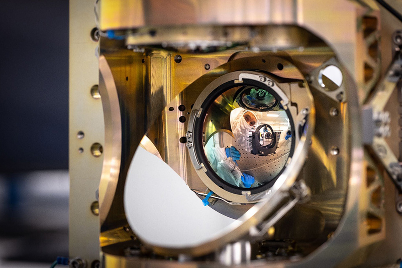
At 03:12 UTC on July 7, 2026, a Falcon 9 lifted off from Vandenberg Space Force Base carrying the heaviest single rideshare payload SpaceX had ever dispatched from California: SpaceX’s Transporter-17 mission. Buried among dozens of small satellites were three boxy 100-kilogram buses built by Muon Space, each carrying an instrument the company calls Quickbeam, a six-channel multispectral infrared imager built for one job: spotting wildfires smaller than a suburban kitchen before they become the next headline (SpaceNews, July 2026).
Two weeks earlier, the same instrument on the FireSat Protoflight demonstrator had imaged a small roadside fire northwest of Medford, Oregon, on June 23, 2025. The fire was missed by every other orbital sensor. By the time ground crews arrived, the flames had burned 0.4 hectares. The Protoflight data, published by the Earth Fire Alliance (EFA) on July 23, 2025, made a quiet case for the constellation now commissioning in low Earth orbit: a new generation of spacecraft designed not to study weather or map land cover, but to catch the first watt of heat a forest fire gives off.
Wildfire managers call the first hour after ignition the golden hour. If a fire is suppressed within sixty minutes of ignition, the cost of attack falls by an order of magnitude; if not, the same fire becomes the kind of runaway that closes highways, evacuates towns, and sends smoke across continents (CAL FIRE briefing, October 2025). The problem is that almost every existing satellite fire product was built for something else. MODIS on Terra and Aqua, the workhorse of orbital fire detection for twenty-five years, returns a pixel every ~1 km. VIIRS on Suomi-NPP and JPSS improves that to 375 m. Both see fires only after they are big enough to saturate the detector, and both push alerts in hours, not minutes, because the data lands in a research processing pipeline rather than a dispatch queue.
What fire agencies wanted was a sensor with three properties that the older instruments could not deliver together: spatial resolution sharp enough to resolve a single-campfire ignition, thermal sensitivity high enough to read temperatures below 600 K without saturating, and a latency path short enough to put an alert into a dispatcher’s screen before the wind changes. Quickbeam is the first instrument designed to satisfy all three (Earth Fire Alliance, program overview, 2025).
Quickbeam is a six-channel multispectral imager spanning short-wave infrared (SWIR), mid-wave infrared (MWIR), and long-wave infrared (LWIR). Three of the channels sit in the SWIR at 1.0–2.5 µm, where they map vegetation moisture and burn scars and pick up reflected sunlight on daylight passes. A single MWIR channel covers 3.0–5.0 µm, the fire-detection sweet spot: hot surfaces near 800 K peak here, and atmospheric transmission is high enough that the band survives most smoke columns. The remaining two channels work the LWIR at 8.0–12.5 µm, useful for background temperature, cloud masks, and the dual-use atmospheric work the U.S. Space Force funded as part of the same instrument (Muon Space product brief, 2025).
The 5 × 5 meter ground sample distance per pixel is roughly forty times finer than what VIIRS delivers in its active-fire band. Each satellite flies in a sun-synchronous orbit at ~600 km altitude and images a 1,500 km swath on every pass. With three satellites phasing that orbit, the constellation returns to any fire-prone region at least twice a day today, with a target of one global revisit per hour by 2029 once the full 50-satellite constellation is in place (Earth Fire Alliance roadmap, 2026).
The hardware underneath the optics matters as much as the optics themselves. FireSat rides on Muon’s Condor-M bus, a 100-kg-class small satellite built around what the company calls a CarefulCOTS approach: every commercial part is selected by analysis for radiation, thermal, vacuum, and shock resilience, then qualified per GSFC-STD-7000 or SMC-S-016 with universal derating per NASA EEE-INST-002 (Muon Space, Condor-M spec sheet, 2025).
The numbers tell the rest of the story. The bus delivers 500 W of peak payload power and 200 W orbit-average, supports 30 Gbps payload data interfaces, and dumps 5 TB per day through its RF downlink (50 TB per day if the customer buys the optical comms option). Pointing knowledge is 5 arcseconds 1σ, control is 15 arcseconds 1σ — fine enough that a 5 m pixel stays a 5 m pixel after stacking. Onboard Δv of 3 km/s lets the constellation maintain its precise spacing without waiting for atmospheric drag to do the work over months.
CarefulCOTS, rather than full radiation hardening, is what lets the satellite cost what it costs. A traditional aerospace IR imager of similar capability can run into the hundreds of millions per copy. FireSat is built to a price point closer to a commercial imaging smallsat, which is the only way a 50-satellite constellation makes sense.
Latency is the part most coverage misses. A fire detection that travels satellite → ground station → processing center → alert API is still thirty minutes old by the time it reaches a dispatcher. FireSat runs a Google Research convolutional neural network directly on the satellite’s edge inference chip, assigning a probability score to every 5 × 5 m tile during the same orbital pass that collected the imagery. Alerts with confidence above 85% are pushed over optical inter-satellite links and dispatched directly into CAL FIRE, US Forest Service, and partner-agency APIs within five minutes of acquisition (Earth Fire Alliance technical brief, 2026).
This is a substantial change in how Earth-observation data flows. The traditional pipeline treats satellites as data factories whose product is then mined by analysts. FireSat treats the satellite as a sensor that produces decisions. The downstream user receives an alert keyed to a confidence score, not a raw image. Below threshold, no alert fires; above, the alert is geo-referenced and time-stamped in the same message.
The three satellites launched on Transporter-17 are now in a three-month commissioning and calibration period, with first operational data expected in October 2026. CAL FIRE, the Colorado Division of Fire Prevention and Control, and agencies in Texas, Oregon, the Amazon, Portugal, Australia, and three African countries are signed up as early adopters. The full constellation target is fifty-plus satellites by 2030, with a goal of a twenty-minute global revisit and a nine-minute revisit for the most fire-prone corridors.
What FireSat is really testing is whether a single-purpose constellation, designed around one metric (median time from ignition to alert), can outperform decades of general-purpose Earth-observation infrastructure. The Protoflight demonstration, the Medford fire, the Oregon roadside ignition nobody else saw: these are the early evidence. If the operational constellation hits its five-minute latency goal at 5 m resolution, the cost-benefit math on wildfire suppression shifts in a way that no amount of MODIS data ever could.
FireSat is a reminder that “satellite for X” can mean something other than “satellite that happens to be useful for X.” Every previous fire-detection system inherited its design from weather, land-imaging, or atmospheric-chemistry missions. Quickbeam was built from a detector layout upward to optimize for the MWIR fire peak, smoke penetration, and edge inference. The constellation is sized not to map the planet but to return to a wildfire fast enough that suppression still works. If it hits its numbers, the next decade of wildfire management will look less like remote sensing and more like an alert service, and the first hour of a fire will start to look very different from the last twenty years.
 Subscribe to our RSS feed







There are no comments.
Add A Comment