


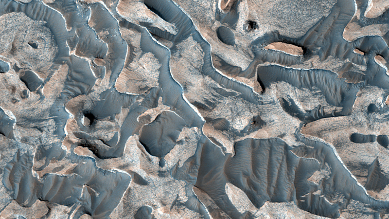
A new overhead image of a Martian crater floor shows branching ridges of pale bedrock winding between darker, dust-floored troughs, an arrangement that looks more like a coral reef than a piece of the red planet. The picture was captured by the High Resolution Imaging Science Experiment, HiRISE, aboard NASA’s Mars Reconnaissance Orbiter and released on September 28, 2026, by HiRISE co-investigator Cathy Weitz of the Planetary Science Institute (Space.com photo of the day for September 28, 2026; Daily Galaxy, September 28, 2026). The terrain sits inside the Arabia Terra region, a vast upland that many planetary geologists regard as one of the oldest, most heavily cratered provinces on Mars. The shapes in the image are not biological. They are layered sedimentary rocks that have been eroded into ridges and pits, and the way those layers repeat across many craters is what makes the image worth a second look. For viewers who only know Mars as a smooth red dot in the night sky, the picture is a reminder of how much texture the planet keeps when you look closely.
What Arabia Terra offers is a stratigraphic archive. Each thin band visible in the rock records a moment in Martian climate history, and the bands stack one on top of another across hundreds of meters of relief. The rhythmic nature of those layers is the whole point. A repeating pattern across a region this large does not arise from one storm, one flood, or one impact; it implies a process that pulsed on and off again and again. The MRO camera that took the picture has been in orbit since 2006, and HiRISE has been returning 25-centimeter-per-pixel images of the Martian surface for almost the entire mission. With more than 100,000 images already on the public catalog, the September 28 release is not a new instrument result. It is a fresh reminder that some of the strongest evidence for an active, water-influenced early climate on Mars has been sitting in the MRO archive for years, waiting for someone to look at it with the right question. The 100,000-image mark was passed in October 2025 on the Syrtis Major plains, and the camera has continued adding observations since.
The deposits were first described as a regional phenomenon in a 2020 paper in JGR Planets by Stack and colleagues (Stack et al. 2020, JGR Planets), who used a combination of HiRISE stereo topography and mineral mapping from the Compact Reconnaissance Imaging Spectrometer for Mars (CRISM) to show that the layered rocks in many Arabia Terra craters share a common stratigraphy. Their preferred explanation was groundwater-fed evaporitic deposition, where water just below the surface cycled up, evaporated, and left behind minerals and fine sediments in regular layers. Lewis and colleagues at the California Institute of Technology had already noted in 2014 (Lewis et al. 2014, JGR Planets) that the rhythmic layering in this part of Mars matches the patterns left by air-fall dust and ash on Earth, which alternate under the influence of orbital cycles. Weitz’s own commentary for the new picture pulls those threads together. The layers are rhythmic, they are widespread, and the most plausible global drivers on Mars are dust storms and groundwater, not isolated local events. Crater counts performed by the same group suggest the layered sequence accumulated mostly during the Hesperian period, roughly 3.0 to 3.7 billion years ago, with the topmost beds stretching into the Amazonian, which is the ongoing geologic era on Mars and the one in which the planet lost most of its surface water. Earlier work by Fergason and Christensen in 2008 had already used thermal imaging to flag the same layered terrain as a candidate record of dust-driven deposition, and the 2020 paper builds on that line of argument.
The image itself is about five kilometers across. The bright ridges are bedrock that has resisted erosion longer than the surrounding material. The darker, bluer-looking troughs are a mix of wind-blown sand and what HiRISE team members call aeolian ripples, the same kind of sand patterns that form under persistent winds in terrestrial deserts. The pits, jagged edges, and crenulated rims the image shows are not the original shapes of the rock. They are erosion scars. Each one marks a layer that has been removed and a layer that has not. The contrast between the two tones is a function of the difference in composition and grain size between the original sediment that hardened into rock and the loose debris that fell on top of it later. HiRISE resolves these textures because it images through three separate color filters and stitches them together; the false-color composites that the team releases are designed to make compositional differences pop, which is why a single scene can look bluish in some places and pinkish in others. HiRISE itself is a 0.5-meter reflecting telescope on MRO, and at MRO’s 250-to-316-kilometer orbit altitude it can pick out features smaller than a meter across. Most of what we know about the fine-scale stratigraphy of Mars has come from that resolution combined with stereo imaging, which lets the team build digital terrain models and measure layer thicknesses down to a fraction of a meter.
The deeper lesson is about how scientists read climate records on a planet that does not have trees, ice cores, or ocean sediment. On Earth, the story of past climate comes from layered archives in lake beds, sea floors, and ice sheets. On Mars, the same role is played by impact craters, which act as ready-made sediment traps and which subsequently get exhumed by wind. Arabia Terra is particularly worth studying because it has been around long enough to have collected material from the Noachian period more than 3.7 billion years ago, when most evidence suggests Mars had a much thicker atmosphere and liquid water on its surface. The layered deposits in the September 28 image are younger than that, but they preserve the same kind of memory. A geologist looking at the rock can read off changes in chemistry, dust load, and water availability across hundreds of millions of years.
A few things remain unsettled. The image does not confirm a single formation mechanism, and the team has been careful not to claim it does. The rhythmic pattern is consistent with several hypotheses, and the right next step is to compare the layer thicknesses and mineralogy from one crater to the next, which the 2020 Stack analysis already started. Future observations from the Mars Reconnaissance Orbiter, and eventually from missions now in development, can sample more of these layered terrains with high-resolution spectroscopy and will be able to test whether groundwater, dust, or volcanic ash dominates the mix. Until then, the picture is best read as a working document: a region that has been taking notes on Martian climate for billions of years, and an instrument still healthy enough to read those notes from orbit.
 Subscribe to our RSS feed









There are no comments.
Add A Comment