


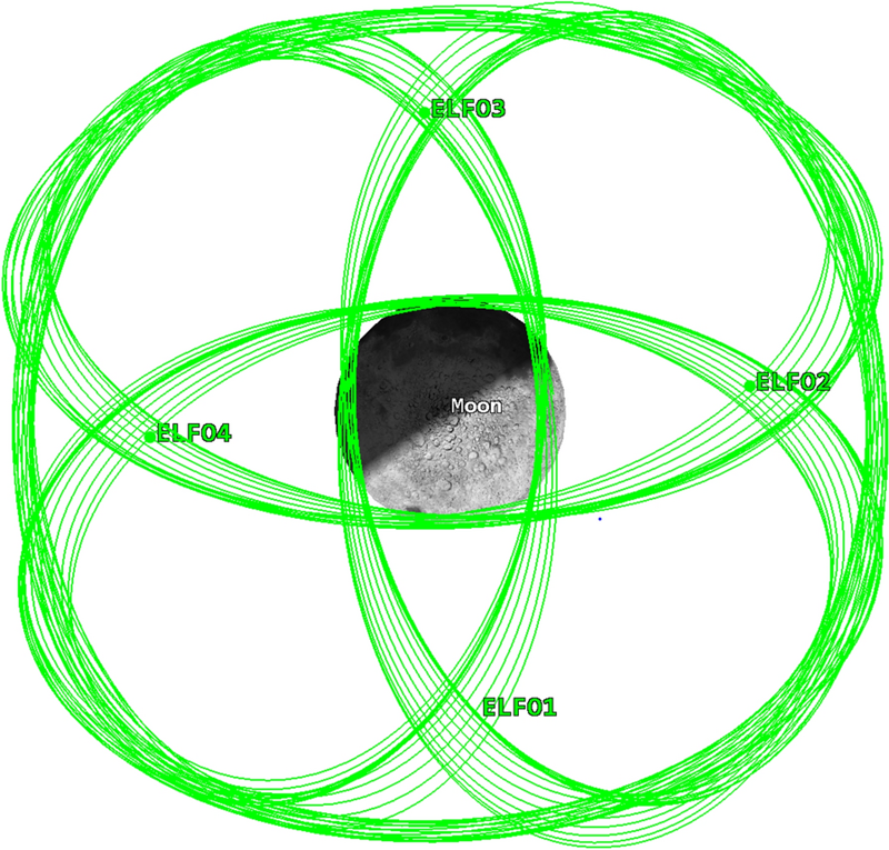
A constellation of navigation satellites can measure the distance between each member with centimeter accuracy and still, slowly, lose track of which way the whole network is pointing. That is the awkward truth at the heart of every Global Navigation Satellite System on Earth, and it is the puzzle researchers at Shanghai’s Microsatellites Engineering Center set out to solve on 17 September 2026 with a paper in Satellite Navigation, announced through EurekAlert. The lead authors were Xia Lin and Baojun Lin, two of the center’s senior engineers. Their answer was to extend the network 384,000 kilometers outward and let four satellites in elliptical orbits around the Moon serve as a gravitational anchor. The result, written up in the open-access journal under a CC BY 4.0 license, is the first end-to-end demonstration that real BeiDou-3 inter-satellite data, paired with simulated lunar cross-links, can keep an autonomous navigation system stable to within roughly 35 centimeters of User Range Error over 60 days, an order of magnitude better than the BeiDou-only baseline.
The reason a spaceborne navigation system needs an anchor at all is that inter-satellite ranging, the technique GPS pioneered in the 1990s and that every modern GNSS now uses to back up its ground stations, has a built-in symmetry problem. Each satellite measures its distance to its neighbors. Those measurements fix the relative geometry of the constellation with high precision, but they cannot distinguish one orientation of the whole network from another, because rotating the constellation rigidly in space leaves every inter-satellite distance exactly the same. Engineers call this property an orientational rank deficiency, and the symptom it produces is a slow rotational drift in the right ascension of the ascending node, the angle that defines where each orbital plane points in inertial space. Without ground-station updates, even a state-of-the-art autonomous system like BeiDou’s accumulates error at a rate of meters per month, which is why every GNSS operator still maintains an expensive global network of monitoring stations as a backup.
The Lin et al. solution exploits a simple geometric fact. A satellite in Earth orbit experiences the Earth’s gravity, which is nearly symmetric about the rotational axis. A satellite in a tight elliptical orbit around the Moon experiences the Moon’s gravity, which is not aligned with Earth’s axis at all. If the entire BeiDou-plus-lunar network were rotated incorrectly as a rigid body, the Earth-orbiting and Moon-orbiting members would no longer respond to their respective gravitational environments in the same way. Earth-Moon cross-links therefore carry information that Earth-only links cannot, and that information breaks the symmetry. The team quantified the change in a particularly clean way. They computed the condition number of the information matrix, a standard mathematical measure of how well-posed a least-squares problem is. For 24 BeiDou Medium Earth Orbit satellites alone, the condition number sat between roughly 10^15 and 10^18, the signature of a numerically singular system. Adding four simulated ELFO satellites dropped the condition number to about 10^2, a fourteen-orders-of-magnitude improvement that signals the symmetry has been fully broken.
The team’s experimental setup is unusually faithful for a navigation study, because half of it is real. They pulled actual on-orbit inter-satellite-link measurements from the operational BeiDou-3 MEO constellation, whose Ka-band TDMA cross-links can resolve ranges with noise floors near 10 centimeters, and combined those measurements with a simulated four-satellite constellation in Elliptical Lunar Frozen Orbits. The ELFO geometry, with four satellites in nearly identical, carefully chosen orbits arranged 90 degrees apart in node, is the same architecture that ESA’s Moonlight initiative and NASA’s LunaNet concept have independently converged on for lunar relay coverage, because ELFOs offer long dwell times over the south pole and remain stable with minimal station-keeping. The team used the well-characterized Sirbu et al. four-ELFO design and ran a 60-day simulation from October through December 2020, processing the BDS-3 data through a Kalman filter that jointly estimated the orbits of all 28 satellites along with clock offsets and Earth rotation parameters. The team also tested the architecture against an additional intermediate scenario in which the BeiDou satellites were allowed to use predicted orbit corrections on their own, an option that captures what an operator could realistically do for the first few weeks of a ground-station outage before the predicted-ephemeris quality decays.
Without any ground-station correction at all, the constellation in the unmitigated scenario drifted by about 7.85 meters of User Range Error after two months. Adding predicted orbital parameters as a partial constraint improved that to 0.6 meters. Adding the four ELFO cross-links dropped it to 0.35 meters, and the three-axis rotation bias was suppressed to 13.59, 10.27, and 4.04 milliarcseconds over the full 60 days. Crucially, the same cross-links help the lunar satellites, too: the four ELFO orbiters reached a maximum three-dimensional position error of 2.26 meters, with radial, along-track, and cross-track components below 0.16 m, 1.7 m, and 1.8 m respectively. The architecture is genuinely two-way. Earth-bound satellites help pin the Moon-bound satellites, and the Moon-bound satellites help pin the Earth-bound ones.
The reason this is more than a clean numerical result is that the cislunar navigation constellations ESA and NASA are actively planning to build for crewed lunar surface operations now have a second job description, as The Brighter Side of News explained in its coverage of the paper. ESA’s Moonlight and NASA’s LunaNet have both been framed primarily as services for south-pole landers, rovers, and astronauts, but if the Lin et al. result holds up in operational hardware, the same lunar relay satellites will quietly double as a stability anchor for the GNSS networks that every other piece of modern infrastructure depends on. A four-satellite lunar constellation costs a small fraction of a full ground-station refresh, and unlike ground stations it cannot be knocked out by a regional communications failure, a cyberattack, or a natural disaster.
Several caveats apply. The lunar portion of the experiment is a simulation, not flight data, and the joint condition-number analysis assumes the Earth-Moon cross-link can be timed to roughly the same precision as the existing BeiDou-3 Ka-band cross-links, which today is straightforward in principle but has not been demonstrated in hardware at 384,000-kilometer range. The 60-day window is also short for a real constellation; whether the drift suppression holds over years, through solar maximum, and across lunar eclipse seasons remains open. The Lin et al. paper is, in their own framing, a preliminary analysis, the first credible end-to-end case that the geometry works, not the last word. The team is appropriately careful about that. The next step that matters is a flight demonstration, likely as a hosted payload on one of the early Moonlight or LunaNet spacecraft, that closes an actual Earth-Moon cross-link and measures the rotational bias suppression directly. The result, when it comes, will tell us whether the 0.35-meter number survives contact with reality. If it does, the architecture of every future GNSS is going to have a footnote about the Moon.
 Subscribe to our RSS feed







There are no comments.
Add A Comment