


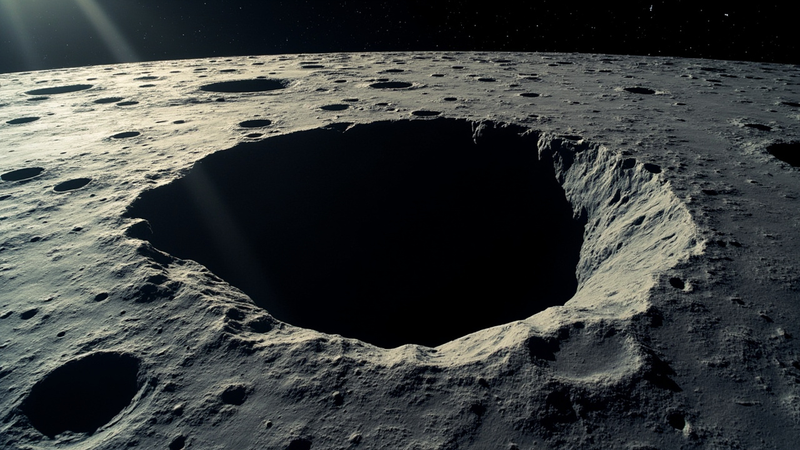
There is a hole on the Moon that has not stopped nagging planetary scientists since they first noticed it. The Marius Hills Pit sits in Oceanus Procellarum, the largest of the lunar maria, in a region already famous for holding the densest collection of volcanic features anywhere on the surface. Lunar Reconnaissance Orbiter images show an opening roughly 50 meters across and somewhere between 30 and 40 meters deep, the floor lost in permanent shadow, the walls exposing layers of basalt that no other spot on the Moon leaves so conveniently within reach. JAXA’s SELENE (Kaguya) spacecraft photographed it in 2009. NASA released the highest-resolution LROC view in 2010. The European Space Agency published its own montage the same decade. And for sixteen years the question has been the same: does the pit lead down into a tube, or is it just a hole?
On October 1, 2026, NASA picked a team to find out (NASA, October 2 2026). The project is called GIMLI — Geophysical Instruments for Marius Lunar pit Investigation — and it will be led by Nathaniel Putzig of the Planetary Science Institute. Honeybee Robotics, the Blue Origin-owned outfit that built the legs for Mars 2020 and the Sample Retrieval Lander arms, will provide the instruments and the project management. The Norwegian Space Agency is contributing the ground-penetrating radar. Co-investigators are spread across Boise State, Johns Hopkins, the Lunar and Planetary Institute, and the University of Oslo. The payload will fly to the surface through NASA’s Commercial Lunar Payload Services (CLPS) initiative under the agency’s Payloads and Research Investigations on the Surface of the Moon (PRISM) program.
What makes GIMLI unusual is the combination. Three independent geophysical methods will be aimed at the same target from the same lander. A ground-penetrating radar will send electromagnetic pulses into the regolith and time their echoes. A gravimeter will measure the local gravity field to a precision high enough to register the slight pull deficit left by an underground void. And a third system — the one Putzig has been waiting to fly for most of his career — will do active-source seismology, the deliberate thumping of the ground with a small explosive or impact source and the recording of how the resulting acoustic wave bounces back. That last technique has not been run on the Moon since Apollo 17 in December 1972 (TechTimes, October 2 2026).
The reason anyone cares whether the tube exists is not the geology. It is the architecture. A lunar day lasts 29.5 Earth days, and the surface temperature swings between roughly +120 and -170 degrees Celsius. Galactic cosmic rays and solar energetic particles deliver the equivalent of a chest x-ray every few seconds to anything exposed. Micrometeoroids the size of sand grains arrive at 70 km/s. A long lava tube, by contrast, holds a near-constant temperature near −20 °C in its interior and provides a meter or more of rock overhead — natural radiation and impact shielding that no inflatable habitat can match. If the Marius Hills Pit really does open into a tube big enough to walk through, the engineering problem of where to put the first permanent lunar base gets substantially easier.
The orbital evidence is already strong. Kaku and colleagues, working with the 4–6 MHz echoes from SELENE’s Lunar Radar Sounder, reported in 2017 a candidate tube roof around 120 meters below the surface near the Marius Hills skylight (Kaku et al., LPSC 2017 abstract 1711). Separately, Chappaz et al. used gravity-gradient data from NASA’s Gravity Recovery and Interior Laboratory (GRAIL) mission to flag a Bouguer anomaly consistent with a low-density void several kilometers east of the pit. Both results are suggestive, not conclusive — orbital radar and gravity can detect a void only in aggregate, with poor horizontal resolution and a strong dependence on what the surrounding rock happens to look like. The case for a usable tube is the kind of question that has to be answered from the surface, with instruments whose geometry is known to within a meter.
Active-source seismology is well suited to that geometry. The classic field setup is two parts: a source — Apollo 17 used a crew-deployed thumper that fired small explosive charges — and a string of geophones that record the wave’s arrival times. The wave’s group velocity depends on the elastic moduli of the material it traverses, and any sharp acoustic-impedance contrast — a void, a frozen-melt boundary, a regolith–bedrock contact — produces a reflection. By shooting from several known source positions and recording on a known array, you can triangulate the depth and shape of the reflector. The technique is what oil and gas geophysicists have used for a century to map the geometry of reservoirs, and it is the same mathematics that Putzig’s team will apply to a 50-meter hole in a mare basalt. The gravimeter is a complement: a void produces a small but measurable decrease in local gravity that a sensitive instrument can isolate, especially when the GPR has already constrained the depth.
The engineering is also a return to first principles. The Apollo 17 Lunar Surface Gravimeter ran from December 1972 to September 1977 and yielded, among other things, the catalog of deep and shallow moonquakes that has been reanalyzed ever since. Modern seismometers are an order of magnitude more sensitive, and modern electronics can run for the multi-day acquisition window the GIMLI survey needs. Honeybee Robotics has not yet published the source design, but the options are well understood: a small explosive launcher, a drop-mass impactor, or a vibroseis-style swept-frequency shaker. Any of the three produces a repeatable signal in the tens-of-hertz band that a 4.5-billion-year-old lava tube would reflect cleanly.
The other thing the survey can do, regardless of whether the tube is there, is tell the volcanic history of the region. The walls of the Marius Hills Pit expose lava-flow stratigraphy that elsewhere on the Moon is buried under hundreds of meters of younger mare basalt. Imaging those layers, and dating the contacts between them, would let geologists read the time sequence of eruptions across one of the Moon’s most prolific volcanic provinces. Even a null result — proof that the pit is just a collapse feature with no associated tube — would be a useful constraint on lava-flow cooling models.
The CLPS lander carrying GIMLI has not been announced, and the launch is likely two to three years away. But the science is already constrained, the team is in place, and the radar-and-seismology combination has not been tried at this scale on another world. When those instruments reach the rim of a 50-meter hole in Oceanus Procellarum, the question the SELENE and GRAIL teams opened in 2017 will finally be settled. Either the Moon has a usable shelter waiting in the Marius Hills, or it does not. Either way, the next twenty years of lunar architecture just got a fact to plan around.
 Subscribe to our RSS feed








There are no comments.
Add A Comment