


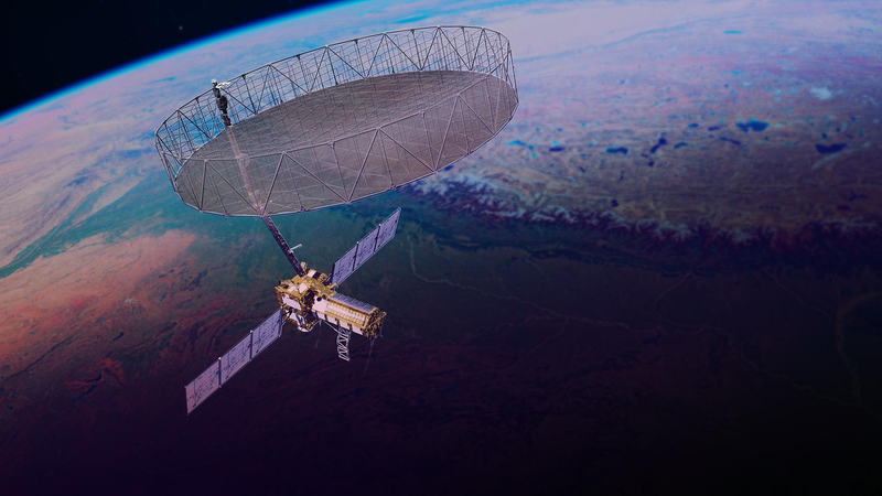
The GSLV Mk II is not, on paper, the most glamorous rocket in the world. It does not chase Falcon 9 reuse statistics, and it has historically been used for the unglamorous work of dropping navigation payloads into geostationary transfer orbit. On July 30, 2026, at 8:10 a.m. Eastern, an Indian GSLV F-16 lifted off from Satish Dhawan Space Centre on the Palk Strait coast, and for the first time in the vehicle’s history it pointed its cryogenic upper stage south-southwest, toward a 747-kilometer sun-synchronous orbit. The payload was a 2,800-kilogram stack that NASA and the Indian Space Research Organisation (ISRO) had spent eleven years building together. NASA called it the most expensive single instrument it had ever flown; ISRO called it the heaviest foreign payload it had ever launched. Within twenty minutes, both ground stations had signal. The spacecraft, NISAR, was healthy on orbit, and the largest unfurlable radar reflector ever launched was still folded against its side (SpaceNews, July 21, 2026).
Earth-observing radar is not new. The European Space Agency’s ERS-1 flew a C-band synthetic aperture radar in 1991. Japan’s ALOS, Germany’s TerraSAR-X, and the Copernicus Sentinel-1 constellation have, between them, turned interferometric SAR (InSAR) into a routine tool for tracking millimeter-scale ground motion across continents. What NISAR adds is two capabilities stacked together: it is the first civilian radar satellite to carry both an L-band system at 1.257 gigahertz (about 24 centimeters wavelength) and an S-band system at 3.2 gigahertz (about 9 centimeters), sharing one 12-meter mesh reflector and one 9-meter boom (NASA, 2026 mission fact sheet).
That dual-frequency design closes a gap that has bedeviled the field for thirty years. L-band penetrates vegetation and dry soil, so it stays coherent over forests and crops long enough to measure slow tectonic creep. S-band is more sensitive to the top surface, so it tracks flood extent, snow wetness, and crop structure. Flying them together means a single pass produces two interferograms that can be differenced to remove atmospheric phase noise. The mission is set to map nearly all of Earth’s land and ice surfaces twice every twelve days, every cycle of 173 orbits, for at least three years (NASA, 2026).
The cost is real: NASA’s contribution sits at roughly $1.2 billion, ISRO’s share at about 7.88 billion rupees ($91 million) in 2017 terms, though the actual figure is higher now (SpaceNews, July 21, 2026). That is the price of joining two cautious space agencies into one program that survived an antenna repair that required a round-trip shipping container between Bangalore and California.
The GSLV F-16’s profile looked normal on paper: liftoff mass around 420 tonnes, the standard S9.4 cryogenic third stage burning liquid hydrogen and liquid oxygen, a 17-meter payload fairing. What was not standard was the orbit. The Satish Dhawan range usually targets 36,000-kilometer geostationary slots, and the polar corridor is dominated by the smaller, solid-fueled PSLV. Pushing a 2,800-kilogram payload with a stowed 12-meter mesh reflector into a sun-synchronous orbit required every kilogram of performance the cryogenic upper stage could deliver, and a launch window that avoided the eclipse season that would have left the stowed reflector swinging through 200-degree temperature swings during deployment.
The earlier slipped target of March 2025 was abandoned because engineers discovered during thermal-vacuum testing that the reflector’s black structural rods would absorb too much solar heat stowed. NASA shipped the antenna back to Goddard Space Flight Center, where technicians applied strips of reflective tape to the rods, and put it on a C-130 back to India in October 2024 (SpaceNews, December 2024). After that, the schedule bowed to ISRO’s launch cadence: the NVS-02 navigation satellite needed the same pad first, six to eight weeks of pad refurbishment followed, and then a slot had to be picked that would keep the spacecraft out of eclipse for at least the first weeks of its commissioning.
When the rocket climbed off the pad on July 30, it did so against a backdrop few in the West paid attention to. ISRO had lost the EOS-09 radar imaging satellite on a PSLV third-stage failure on May 17, 2026, and the NVS-02 navigation satellite had been stranded in the wrong orbit in January after a propellant valve failed to open. Neither hardware line is shared with GSLV, but the question of process discipline was in the air. The July 21 press conference that confirmed the launch date did not include a single ISRO representative, a fact NASA attributed to the time difference but which industry sources flagged as unusual (SpaceNews, July 21, 2026). Two days after launch, both parties confirmed that the spacecraft was operating normally and that solar array deployment had succeeded.
The most counter-intuitive thing about NISAR is that it is not, strictly, an imaging instrument. A SAR builds an image by emitting a chirped radar pulse, listening to the echo, and using the platform’s forward motion to synthesize an antenna tens of kilometers long. Range resolution comes from the chirp bandwidth (NISAR’s L-band transmits 80 megahertz of bandwidth, giving roughly 2 meters of slant-range resolution; S-band transmits 37.5 megahertz for about 5 meters). Azimuth resolution comes from Doppler processing of the returns along the flight track. The signal is recorded in phase, so a second pass from almost the same position lets you subtract two images and recover ground displacement to the centimeter level. The relation is:
Δr = λ / (4π) * Δφ
where λ is the radar wavelength and Δφ is the wrapped interferometric phase. At L-band, a phase change of one radian corresponds to about two centimeters of line-of-sight motion.
The reflector is the engineering showpiece. Stowed, it fits inside a 1.5-meter collar; deployed, it becomes a 12-meter ribbed disk covered in gold-plated molybdenum wire mesh. The 9-meter boom that holds the feed assembly is built from composite truss segments that unfold in a sequence to avoid contact with the reflector surface; the whole assembly weighs about 145 kilograms. NASA and Astro Aerospace invented a new hinge mechanism because earlier mesh reflectors of this diameter were not designed for the thermal cycling of a sun-synchronous dawn-dusk orbit.
The orbit itself is part of the engineering story. NISAR flies in a 6 a.m. / 6 p.m. ascending-node sun-synchronous configuration, which gives consistent illumination across the 12-day cycle. The exact repeat of 173 orbits in 12 days constrains the swath to about 242 kilometers, which in turn constrains the antenna geometry. The mission team designed a ScanSAR mode in which the radar beam is electronically steered across five sub-swaths in elevation, then assembled into a wide swath at the cost of coarser azimuth resolution. NISAR will operate primarily in this mode.
Finally, the data pipeline. NASA’s Alaska Satellite Facility DAAC will host the L-band data; ISRO’s Bhoonidhi portal will host the S-band data. Both agencies committed to a 24-hour urgent-acquisition capability: within a day of a magnitude-7 earthquake, NISAR could re-point to map the coseismic deformation field over hundreds of kilometers.
If commissioning goes as planned, NISAR will begin science operations in October 2026, after roughly ninety days of radar calibrations, antenna deployments, and orbit trim maneuvers. Early months of data will be dominated by earthquakes, glacier flow, and agricultural calibration campaigns over the US Corn Belt. Within a year, NISAR should be producing the most consistent global interferometric stack ever assembled, a baseline that will outlast Sentinel-1C and ALOS-4.
The broader lesson is older than radar. Eleven years, two agencies, 2,800 kilograms, one reflector, two frequencies. Earth observation at this scale is no longer a single-country program. What NISAR proves is that two different bureaucracies can still agree on what a centimeter means.
 Subscribe to our RSS feed









There are no comments.
Add A Comment