AIS, which stands for Automatic Identification System, provides navigation aid and works as an anti-collision system for vessels at sea. As of December 31, 2004, as required by IMO (the International Maritime Organization), an AIS device must be fitted aboard all passenger ships, all ships engaged on international voyages that have more than 300 gross tonnage, and cargo ships not engaged on international voyages that have more than 500 gross tonnage.
AIS devices aboard the ships broadcast messages containing position reports and short messages with information about the ship and the voyage. These messages are sent on two channels in the maritime VHF to neighboring vessels and to VTS (Vessel Traffic Services) stations on the shore. These messages can also be picked up by a VHF receiver in low Earth orbit (LEO). This is how the idea of space monitoring of AIS signals was born.
Norway, a nation having long shore lines and large fishing grounds in its coastal waters, pioneered this new concept. AISsat-1 is a nanosatellite technology demonstration mission in LEO, funded by the NSC (the Norwegian Space Center). The technical implementation is the responsibility of the FFI (Norwegian Defense Research Establishment).
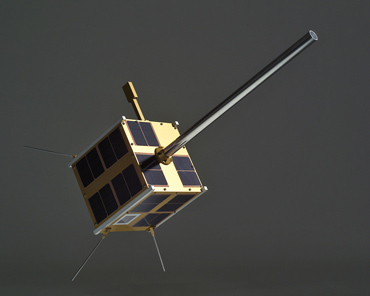
AISsat-1 is a cube-shaped nanosatellite measuring 20 x 20 x 20 cm that weighs six kilograms. AISsat-1 has been built at UTIAS (the University of Toronto Institute for Aerospace Studies). The payload on AISsat-1, the AIS sensor, was developed by Kongsberg Seatex AS (KSX) of Trondheim, Norway.
The satellite design is based on the Generic Nanosatellite Bus (GNB) developed at UTIAS. GNB contains all the necessary components for a typical satellite mission: a TT&C and payload data communication system, a 3-axis attitude determination and control system, and a dual-battery, gallium-arsenide triple-junction solar cell based power system. GNB has a large accommodation for scientific payloads in terms of volume, power, computing power, and spacecraft surface area.
AISsat-1 shared a ride to space on a multi-payload mission on the PSLV-C15 launch vehicle on July 12, 2010. PSLV lifted off from Satish Dhawan Space Centre (SDSC), Sriharikota, India. The satellite has been placed into a polar orbit at 98.1 degrees inclination with perigee at 626 km and apogee at 642 km. The orbit has a period of 97.3 minutes.
The ground station that acquires data from AISsat-1 during the 15 daily passes over Norwegian waters is the Svalbard Ground Station, located on the Norwegian Svalbard archipelago, near the town of Longyearbyen. The ground station is storing data for subsequent forwarding to the mission control center located at FFI in southern Norway.
AISsat-1 has entered the Norwegian Top Technological Achievement Competition for 2010. You are invited to cast your vote for AISsat-1, a mission based on Canadian nanosatellite technology. You can submit your vote by the end of this Sunday, November 28, 2010, on this webpage. If you have difficulties understanding Norwegian, this Google Translate link will do the trick for you. Go Canada!
You can find more information about AISsat-1 on the Norwegian Space Centre’s website.


 Subscribe to our RSS feed


There are no comments.
Add A Comment