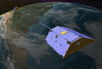
While the preparations for ESA’s GOCE mission are under way, NASA already has its own gravity mapping mission called GRACE, which was launched in March 2002.
NASA teamed up with the German Space Agency to launch GRACE (Gravity Recovery And Climate Experiment).
GRACE currently provides detailed measurements of the Earth’s gravity field, and these measurements help scientists better understand the effects of gravity on global climate change, oceans, and land masses. This will lead to better predictions about changes in water supply, weather forecasts, and natural hazards.
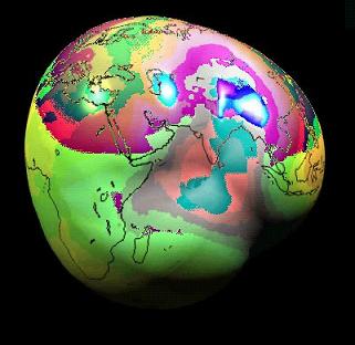
The data gathered by GRACE has been used to create the best map to date of Earth’s gravitational field. While common sense and introductory physics textbooks tell us that the weight of an object should not have different values at different locations on the surface of the Earth, measurements taken indicate that there are areas where gravity is slightly stronger or weaker than the average. Many of the peaks or valley on the maps put together by scientists can be attributed to surface features, like ridges or mountains. However, there are cases when the variations cannot be explained, and they might be related to high or low sub-surface densities.
The maps compiled from the scientific data returned by GRACE are 1,000 times more accurate then maps previously produced.
The GRACE mission consists of two satellites flying one behind another in near circular orbits at an altitude of 460 km and about 220 km apart. The satellites have really neat nicknames: Tom and Jerry. The leading satellite (that would be Jerry) sends a microwave signal to the trailing satellite (Tom) to precisely measure the distance between the two. GRACE can detect very small changes in the distance that separates the two spacecraft, down to one-tenth of the width of a human hair. The Global Positioning System (GPS) onboard Tom and Jerry is used to determine the precise location of the measurement taken.
What is the science involved in taking these measurements? When a satellite passes over an area where the gravity is stronger, it will experience a stronger gravitational pull and increase its speed. Conversely, the speed of the satellite will decrease when passing over areas with weaker gravity.
Going back to the satellites, the variations in the gravity field will cause the distance between the two spacecraft to vary slightly. On the ground, the measurements of the distance between the GRACE satellites are translated into variations of the gravity field, and this is how the maps are compiled.
GRACE maps the entire gravity field of Earth every thirty days. The snapshots allow the detection of changes in the polar ice sheets, sea level, ocean currents, the Earth’s water cycle, and even the interior structure of the Earth.
The list of applications is impressive. Measurements over ice sheets can indicate decreases in the ice sheet’s mass. Decreases in gravity can also indicate drying river basins. And not just changes in water above the ground can be measured, but also water stored in aquifers beneath the surface.
For more information about GRACE check out NASA’s web site or the dedicated web page at the University of Texas at Austin.


 Subscribe to our RSS feed


There are no comments.
Add A Comment