OrbitalHub

The place where space exploration, science, and engineering meet

Domain is for sale. $50,000,000.00 USD. Direct any inquiries to contact@orbitalhub.com.

Archive for September, 2017

September 27, 2017

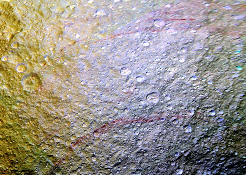
Red Arcs on Tethys

Posted by


NASA dixit:

“April 11, 2015. Unusual arc-shaped, reddish streaks cut across the surface of Saturn’s ice-rich moon Tethys in this enhanced-color mosaic. The red streaks are narrow, curved lines on the moon’s surface, only a few miles (or kilometers) wide but several hundred miles (or kilometers) long. The red streaks are among the most unusual color features on Saturn’s moons to be revealed by Cassini’s cameras.

A few of the red arcs can be faintly seen in Cassini imaging observations made earlier in the mission, but the color images for this observation, which were obtained in April 2015, were the first to show large northern areas of Tethys under the illumination and viewing conditions necessary to see the features clearly. As the Saturn system moved into its northern hemisphere summer over the past few years, northern latitudes have become increasingly well illuminated. As a result, the red arc features have become clearly visible for the first time.

The origin of the features and their reddish color is currently a mystery to Cassini scientists. Possibilities being studied include ideas that the reddish material is exposed ice with chemical impurities, or the result of outgassing from inside Tethys. The streaks could also be associated with features like fractures that are below the resolution of the available images.

Except for a few small craters on Dione, reddish tinted features are rare on other moons of Saturn. However, many reddish features are observed on the geologically young surface of Jupiter’s moon Europa.

Images taken using clear, green, infrared and ultraviolet spectral filters were combined to create the view, which highlights subtle color differences across Tethys’ surface at wavelengths not visible to human eyes. The moon’s surface is fairly uniform in natural color. The yellowish tones on the left side of the view are a result of alteration of the moon’s surface by high-energy particles from Saturn’s magnetosphere. This particle radiation slams into the moon’s trailing hemisphere, modifying it chemically and changing its appearance in enhanced-color views like this one.

The area of Tethys shown here is centered on 30 degrees north latitude, 187 degrees west longitude, and measures 305 by 258 miles (490 by 415 kilometers) across. The original color images were obtained at a resolution of about 2,300 feet (700 meters) per pixel. This is a mosaic of images that have been photometrically calibrated and map-projected.”

Image credit: NASA/JPL-Caltech/Space Science Institute


  • Facebook
  • Google
  • Slashdot
  • Reddit
  • Live
  • TwitThis
September 27, 2017

Satellite Animation Shows Hurricanes

Posted by


NASA dixit:

“This animation of NOAA’s GOES East satellite imagery from Sept. 21 at 7:45 a.m. EDT (1145 UTC) to Sept. 23 ending at 7:45 a.m. EDT (1145 UTC) shows Jose becoming a post-tropical storm winding down near New England while Hurricane Maria moved over Puerto Rico and toward the Bahamas.”

Video credit: NASA


  • Facebook
  • Google
  • Slashdot
  • Reddit
  • Live
  • TwitThis
September 26, 2017

Subtle Colors on Iapetus

Posted by


NASA dixit:

“March 27, 2015. Cassini stared toward Saturn’s two-toned moon Iapetus (914 miles or 1,471 kilometers across) for about a week in early 2015, in a campaign motivated in part to investigate subtle color differences within the moon’s bright terrain. This distant flyby represents Cassini’s second-closest approach to Iapetus in the current mission phase. It is the only set of observations with a good view of the bright terrain in the moon’s north polar area.

The large basin at lower right, within the dark terrain, is named Turgis. The slightly smaller crater at the nine o’clock position is Falsaron. The two prominent craters just above image center are Roland and Turpin. At the limb around the three o’clock position is the darkened rim of the crater Naimon. Images taken using red, green and blue spectral filters were combined to create this natural-color view. The moon’s brightness has been enhanced in order to make the dark terrain visible. The image also was enlarged by a factor of two compared to the original data.

The view was obtained by the Cassini spacecraft narrow-angle camera at a distance of approximately 621,000 miles (1 million kilometers) from Iapetus and at a Sun-Iapetus-spacecraft, or phase, angle of 38 degrees. Image scale on Iapetus is about 4 miles (6 kilometers).

The image was produced by Tilmann Denk at Freie Universität in Berlin.”

Image credit: NASA/JPL-Caltech/Space Science Institute


  • Facebook
  • Google
  • Slashdot
  • Reddit
  • Live
  • TwitThis
September 26, 2017

A Slingshot from Earth

Posted by


NASA dixit:

“OSIRIS-REx is NASA’s mission to explore near-earth asteroid Bennu, collect a sample, and return it to Earth. To get to Bennu, however, OSIRIS-REx must first leave the plane of Earth’s orbit and match the orbital tilt of its target. On September 22, 2017, OSIRIS-REx approached Earth and flew over its southern hemisphere, passing within 11,000 miles of Antarctica. This gravitational slingshot will bend its trajectory by six degrees, sending the spacecraft on a path to intercept Bennu. Shortly after the flyby, OSIRIS-REx looked back at Earth and took images and spectra, ensuring that its instruments are ready for arrival at Bennu in 2018.”

Video credit: NASA’s Goddard Space Flight Center/Dan Gallagher


  • Facebook
  • Google
  • Slashdot
  • Reddit
  • Live
  • TwitThis
September 25, 2017

Rhea in Relief

Posted by


NASA dixit:

“February 10, 2015. Surface features on Rhea – mostly impact craters in this image – are thrown into sharp relief thanks to long shadows. Viewing this terrain near the day/night terminator makes it easier to appreciate just how violent Rhea’s geological history has been. The craters on Rhea (949 miles, or 1,527 kilometers across) are the result of 4.6 billion years of bombardment by small bodies. With very little erosion, the scars and craters remain unless they are overwritten by other, newer impacts.

This view looks toward the anti-Saturn hemisphere of Rhea. North on Rhea is up and rotated 11 degrees to the right. The image was taken in visible light with the Cassini spacecraft narrow-angle camera. The view was acquired at a distance of approximately 47,000 miles (76,000 kilometers) from Rhea. Image scale is 1,500 feet (460 meters) per pixel.”

Image credit: NASA/JPL-Caltech/Space Science Institute


  • Facebook
  • Google
  • Slashdot
  • Reddit
  • Live
  • TwitThis
September 25, 2017

September Solar Flares

Posted by


ESA dixit:

“The Sun unleashed powerful solar flares on September 6, one of which was the strongest in over a decade. An X2.2-class flare was launched at 09:10 GMT and an X9.3 flare was observed at 12:02 GMT. An M-class flare was also observed two days earlier on September 4.

The images were captured by the ESA/NASA Solar and Heliospheric Observatory, SOHO. The flares were launched from a group of sunspots classified as active region 2673. The shaded disc at the centre of the image is a mask in SOHO’s LASCO instrument that blocks out direct sunlight to allow study of the faint details in the Sun’s corona. The white circle added within the disc shows the size and position of the visible Sun.”

Video credit: ESA


  • Facebook
  • Google
  • Slashdot
  • Reddit
  • Live
  • TwitThis