 |
| Credits: ESA-AOES Medialab |
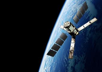
The Soil Moisture and Ocean Salinity (SMOS) mission, which is the second Earth Explorer Opportunity mission to be developed as part of ESA’s Living Planet Program, will provide global maps of moisture over the Earth’s landmasses and salinity over the oceans. These observations will improve our understanding of hydrology and ocean circulation patterns.
The science objectives for the SMOS mission are global monitoring of surface soil moisture and surface salinity over oceans, and improving the characterization of ice and snow-covered surfaces.
The SMOS satellite is built around a standard spacecraft bus called Proteus, which was developed by the French space agency CNES (Centre National d’Etudes Spatiales) and Alcatel Alenia Space. Proteus measures one cubic meter and plays the role of a service module, hosting all the subsystems that are required for the satellite to function.
A GPS receiver collects satellite position information. A hydrazine monopropellant system consisting of four 1-Newton thrusters, which are mounted on the base of the spacecraft, provides the thrust for orbit control. Three 2-axis gyroscopes and four small reaction wheels control the attitude of the satellite. A star tracker also provides accurate attitude information for instrument measurements.
The solar panels can produce up to 900 W, covering the 525 W maximum payload consumption. During eclipse periods, the satellite uses a 78 AH Li-ion battery. SMOS has a launch mass of 658 kg: a 275 kg platform, 355 kg payload, and 28 kg of fuel.
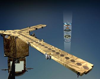
The SMOS satellite will deploy a new type of scientific instrument in space: a microwave imaging radiometer that operates between 1,400 – 1,427 MHz (L-band). The instrument is called Microwave Imaging Radiometer using Aperture Synthesis, or MIRAS, for short. MIRAS consists of a central structure and three deployable arms, and uses 69 antenna-receivers (LICEFs) for measuring microwave radiation emitted from the surface of the Earth. The instrument is the result of almost ten years of research and development.
 |
| Credits: ESA-AOES Medialab |
The data collected by MIRAS needs to go through a validation process. The radiation received by the instrument is a function that depends not only on soil moisture and ocean salinity, other effects need to be considered when instrument data is converted into units of salinity and moisture.
Factors that have to be considered are the distribution of vegetation, the litter layer, the soil type, the varying roughness of the surface, and the physical temperature of the surface of the land and sea.
In order to quantify the effects of factors mentioned above, dedicated campaign activities were conducted. Ground-based and airborne instruments similar to the one mounted on SMOS were used to collect data that was correlated with in-situ observations made by large ground teams. Long-term observations were carried out from an oilrig platform in the Mediterranean and at the Concordia Station in Antarctica.
The Committee on Earth Observation Satellites (CEOS) has defined a number of levels for the SMOS Mission Data Products. They range from Raw Data to Level-3 Data Products, which are Soil Moisture and Ocean Salinity global maps. Level-3 data will be available from the SMOS Level 3/4 Processing Center in Spain.
Eurockot will provide the launch services for the SMOS mission. A Rockot launcher, which is derived from a Russian Intercontinental Ballistic Missile (ICBM) SS-19, will lift off from the Plesetsk Cosmodrome, 800 km north of Moscow. The Rockot launcher will inject the satellite in a 758 km quasi-circular orbit.
The CNES Satellite Operations Ground Segment and ESA/CDTI (Centro para el Desarrollo Technologico Industrial) Data Processing Ground Segment will be responsible for the SMOS mission ground segment.
Initially scheduled for 2008, the launch of the Earth Explorer SMOS satellite will take place some time from July to October 2009.
You can find more details about SMOS on the dedicated page on ESA’s web site.


 Subscribe to blog posts using RSS


