OrbitalHub

The place where space exploration, science, and engineering meet

Domain is for sale. $50,000,000.00 USD. Direct any inquiries to contact@orbitalhub.com.

Archive for the Cassini Images category

October 12, 2017

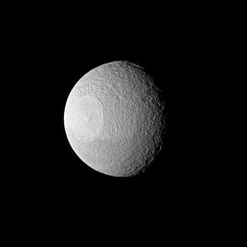
Tethys

Posted by


NASA dixit:

“November 10, 2016. Tethys, one of Saturn’s larger icy moons, vaguely resembles an eyeball staring off into space in this view from NASA’s Cassini spacecraft. The resemblance is due to the enormous crater, Odysseus, and its complex of central peaks. Like any solar system moon, Tethys (660 miles or 1,062 kilometers across) has suffered many impacts. These impacts are a prime shaper of the appearance of a moon’s surface , especially when the moon has no active geological processes. In this case, a large impact not only created a crater known as Odysseus, but the rebound of the impact caused the mountainous peaks, named Scheria Montes, to form in the center of the crater.

This view looks toward the leading side of Tethys. North on Tethys is up and rotated 1 degree to the left. The image was taken in green light with the Cassini spacecraft narrow-angle camera. The view was acquired at a distance of approximately 228,000 miles (367,000 kilometers) from Tethys. Image scale is 1.2 miles (2 kilometers) per pixel.”

Image credit: NASA/JPL-Caltech/Space Science Institute


  • Facebook
  • Google
  • Slashdot
  • Reddit
  • Live
  • TwitThis
October 11, 2017

Coy Dione

Posted by


NASA dixit:

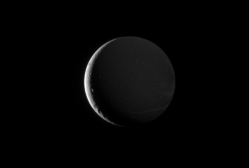
“October 23, 2016. Dione’s lit hemisphere faces away from Cassini’s camera, yet the moon’s darkened surface features are dimly illuminated in this image, due to Saturnshine. Although direct sunlight provides the best illumination for imaging, light reflected off of Saturn can do the job as well. In this image, Dione (698 miles or 1,123 kilometers across) is above Saturn’s day side, and the moon’s night side is faintly illuminated by sunlight reflected off the planet’s disk.

This view looks toward the Saturn-facing side of Dione. North on Dione is up and rotated 8 degrees to the right. The image was taken in visible light with the Cassini spacecraft narrow-angle camera. The view was obtained at a distance of approximately 313,000 miles (504,000 kilometers) from Dione. Image scale is 1.8 miles (3 kilometers) per pixel.”

Image credit: NASA/JPL-Caltech/Space Science Institute


  • Facebook
  • Google
  • Slashdot
  • Reddit
  • Live
  • TwitThis
October 10, 2017

Mimas’ Mountain

Posted by


NASA dixit:

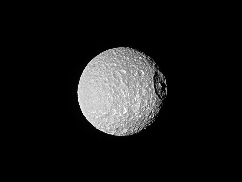
“October 22, 2016. Shadows cast across Mimas’ defining feature, Herschel Crater, provide an indication of the size of the crater’s towering walls and central peak. Named after the icy moon’s discoverer, astronomer William Herschel, the crater stretches 86 miles (139 kilometers) wide, almost one-third of the diameter of Mimas (246 miles or 396 kilometers) itself. Large impact craters often have peaks in their center. Herschel’s peak stands nearly as tall as Mount Everest on Earth.

This view looks toward the anti-Saturn hemisphere of Mimas. North on Mimas is up and rotated 21 degrees to the left. The image was taken with the Cassini spacecraft narrow-angle camera using a combination of spectral filters which preferentially admits wavelengths of ultraviolet light centered at 338 nanometers. The view was acquired at a distance of approximately 115,000 miles (185,000 kilometers) from Mimas and at a Sun-Mimas-spacecraft, or phase, angle of 20 degrees. Image scale is 3,300 feet (1 kilometer) per pixel.”

Image credit: NASA/JPL-Caltech/Space Science Institute


  • Facebook
  • Google
  • Slashdot
  • Reddit
  • Live
  • TwitThis
October 9, 2017

Hyperion

Posted by


NASA dixit:

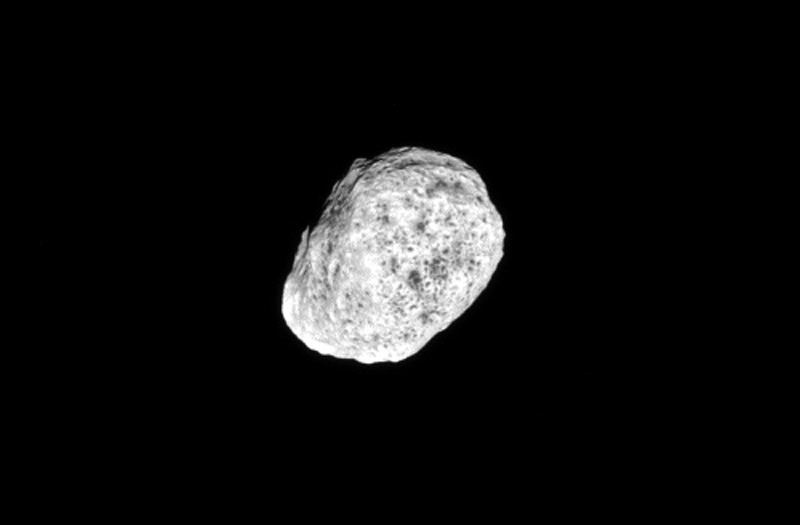
“August 22, 2016. The moon Hyperion tumbles as it orbits Saturn. Hyperion’s (168 miles or 270 kilometers across) spin axis has a chaotic orientation in time, meaning that it is essentially impossible to predict how the moon will be spinning in the future. So far, scientists only know of a few bodies with such chaotic spins. The image was taken in green light with the Cassini spacecraft narrow-angle camera.

The view was acquired at a distance of approximately 203,000 miles (326,000 kilometers) from Hyperion and at a Sun-Hyperion-spacecraft, or phase, angle of 10 degrees. Image scale is 1 mile (2 kilometers) per pixel.”

Image credit: NASA/JPL-Caltech/Space Science Institute
 

  • Facebook
  • Google
  • Slashdot
  • Reddit
  • Live
  • TwitThis
October 8, 2017

Lonely Moon

Posted by


NASA dixit:

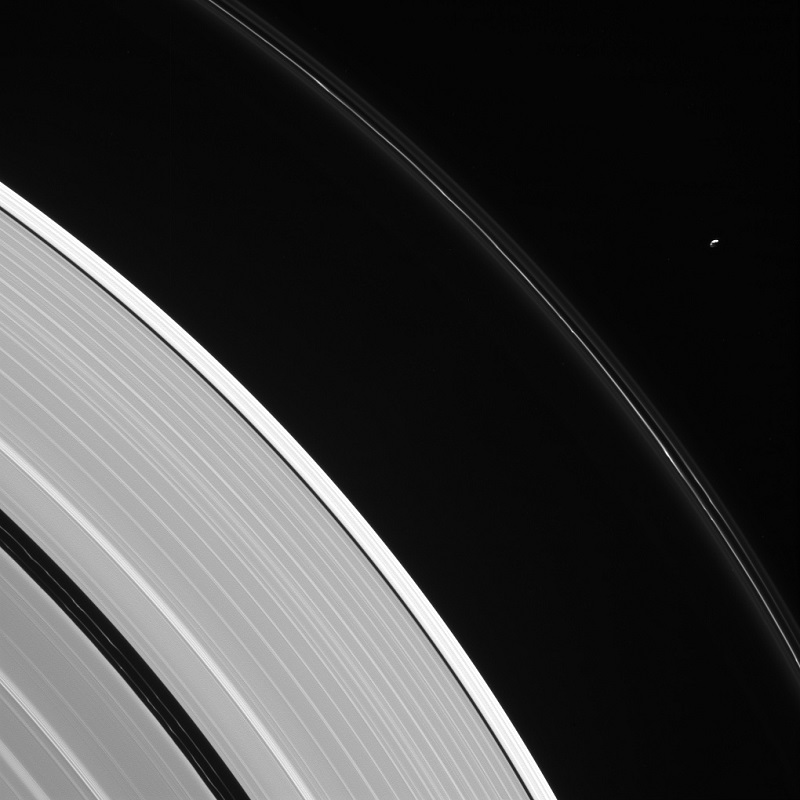
“August 12, 2016. Pandora is seen here, in isolation beside Saturn’s kinked and constantly changing F ring. Pandora (near upper right) is 50 miles (81 kilometers) wide. The moon has an elongated, potato-like shape. Two faint ringlets are visible within the Encke Gap, near lower left. The gap is about 202 miles (325 kilometers) wide. The much narrower Keeler Gap, which lies outside the Encke Gap, is maintained by the diminutive moon Daphnis (not seen here).

This view looks toward the sunlit side of the rings from about 23 degrees above the ring plane. The image was taken in visible light with the Cassini spacecraft narrow-angle camera. The view was acquired at a distance of approximately 907,000 miles (1.46 million kilometers) from Saturn and at a Sun-Saturn-spacecraft, or phase, angle of 113 degrees. Image scale is 6 miles (9 kilometers) per pixel.”

Image credit: NASA/JPL-Caltech/Space Science Institute


  • Facebook
  • Google
  • Slashdot
  • Reddit
  • Live
  • TwitThis
October 7, 2017

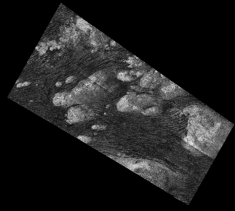
Flowing Dunes of Shangri-La

Posted by


NASA dixit:

“July 25, 2016. In the Shangri-La Sand Sea on Titan is shown in this image from the Synthetic Aperture radar (SAR) on NASA’s Cassini spacecraft. Hundreds of sand dunes are visible as dark lines snaking across the surface. These dunes display patterns of undulation and divergence around elevated mountains (which appear bright to the radar), thereby showing the direction of wind and sand transport on the surface. Sands being carried from left to right (west to east) cannot surmount the tallest obstacles; instead, they are directed through chutes and canyons between the tall features, evident in thin, blade-like, isolated dunes between bright some features. Once sands have passed around the obstacles, they resume their downwind course, at first collecting into small, patchy dunes and then organizing into larger, more pervasive linear forms, before being halted once again by obstacles.

These patterns reveal the effects not only of wind, perhaps even modern winds if the dunes are actively moving today, but also the effects of underlying bedrock and surrounding topography. Dunes across the solar system aid in our understanding of underlying topography, winds and climate, past and present. Similar patterns can be seen in dunes of the Great Sandy Desert in Australia, where dunes undulate broadly across the uneven terrain and are halted at the margins of sand-trapping lakes. The dune orientations correlate generally with the direction of current trade winds, and reveal that winds must have been similar back when the dunes formed, during the Pleistocene glacial and interglacial periods.

North on Titan is up in the image. Radar illuminates the scene from upper right at a 27-degree incidence angle. The image was obtained during the mission’s 122nd targeted Titan encounter.”

Image credit: NASA/JPL-Caltech/Space Science Institute


  • Facebook
  • Google
  • Slashdot
  • Reddit
  • Live
  • TwitThis