OrbitalHub

The place where space exploration, science, and engineering meet

Domain is for sale. $50,000,000.00 USD. Direct any inquiries to contact@orbitalhub.com.


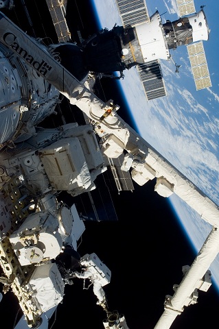
Credits: NASA

The 140 companies and organizations listed in the Canadian Space Directory generated $3.44 billion CDN in revenue and employed over 8000 Canadians in 2010, according to the 2010 State of the Canadian Space Sector Report. These firms support the technologies required for weather forecasting, remote sensing, GPS systems, satellite and cable television, remote phone communication systems and even our Canadian astronautcorps.


They also provide equipment and technical support to scientists performing experiments and developing new technologies related to astronomy, Earth sciences, medicine and many other fields at over a dozen university faculties located throughout the country plus facilitate communications and space situational awareness for our Canadian military in the far North for Arctic sovereignty and on missions throughout the world. Taken together, these companies, the educational facilities developing new innovations, our military, plus the government and industry organizations and the facilities they utilize represent our critical Canadian space infrastructure.


But this infrastructure is in a state of crisis. What must we do to protect, support and grow this disparate group of private and public organizations, capabilities and supporting infrastructure? Join us to find out at this full day discussion of Canada’s future in space.


The Canadian Space Commerce Association 2012 Conference is featuring:

• Joan Harvey – Head of Research &Analysis, Policy and External Relations, Canadian Space Agency (CSA)
• Maryse Harvey and/or Jim Quick – VPand CEO, respectively, Aerospace IndustriesAssociation of Canada
• Dr. Christian Feichtinger – Executive Director, International Astronautical Federation
• Alex Saltmann – Executive Director, Commercial Space Flight Federation
• Robert Godwin – Director, Canadian Air and Space Museum, and Owner, Apogee Books
• Dr. Arsen Hajian – Arjae Spectral Enterprises
• Ron Holdway – President, Canadian Aeronautics and Space Institute, and VP of Government Relations, Com Dev International
• ScottLarson – President, Urthe Cast
• Dr. Gordon Osinski – NSERC/MDA/CSA Industrial Research Chair in Planetary Geology, University of Western Ontario
• Larry Reeves – Director, Canadian Satellite and Design Challenge (CSDC)
• Nobina Robinson – CEO, Polytechnics Canada, and member of the Review of Federal Support to Research and Development (the Jenkins Panel)
• Kevin Shortt – President, Canadian Space Society
• Cliff Sosnow – Chair of the International Trade and Investment Group, Blake, Cassels & Graydon LLP
• Michael Woods –Partner, Heenan Blaikie Law Firm


Date & Time: Wednesday, March 28th, 2012, 8:30 AM – 5:30 PM, with a Networking & Social Eventat 7:00 PM


Location: National Arts Centre, Fountain Room, 53 Elgin Street, Ottawa, Ontario, K1P 5W1, Canada


CSCA is looking for three speakers on the topic of their start-up commercial space venture modeled on the format of the O’Reilly’s Ignite Talks under the motto “Enlighten Us, But Make It Quick!”. Anyone who is interested should submit an abstract with contact information and a 5-minute presentation for consideration, to Marc Boucher.


CSCA is looking for two volunteers for the CSCA 2012 Conference. If you are interested in this opportunity, please email Farnaz Ghadaki.


To find out more about this event, please visit the Canadian Space CommerceAssociation website. For registration, please visit: http://2012canadianspacecommerceassociation.eventbrite.com/


  • Facebook
  • Google
  • Slashdot
  • Reddit
  • Live
  • TwitThis
01-17-10

Sentinel

Posted by


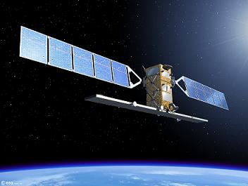
Credits: ESA – P.Carril


The European Union’s Global Monitoring for Environment and Security (GMES) initiative was born as the result of a growing need for accurate and accessible information about the environment, the effects of climate change, and civil security. GMES uses as its main information feed the data collected by satellites developed by ESA. Data is also collected by instruments carried by aircraft, floating in the ocean, or located on the ground.


GMES provides services that can be grouped into five main categories: land management, marine environment, atmosphere, aid emergency response, and security.


There are five Sentinel missions designed as components of the GMES initiative. These missions will complement the national initiatives of the EU members involved. The missions will collect data for land and ocean monitoring, and atmospheric composition monitoring, making use of all-weather radar and optical imaging. Each of the Sentinel missions is based on a constellation of two satellites.


Sentinel-1 is an all-weather radar-imaging mission. The satellites will have polar orbits and collect data for the GMES land and ocean services. The first satellite is scheduled for launch in 2012. Sentinel-1 will ensure the continuity of Synthetic Aperture Radar (SAR) applications, taking over from systems carried by ERS-1, ERS-2, Envisat, and Radarsat. Sentinel-1 satellites will be carried to orbit by Soyuz launch vehicles lifting off from Kourou.


Sentinel-2 will provide high-resolution multi-spectral imagery of vegetation, soil, and water, and will cover inland waterways and coastal areas. Sentinel-2 is designed for the data continuity of missions like Landsat or SPOT (Satellite Pour l’Observation de la Terre). Each satellite will carry a Multi-Spectral Imager (MSI) that can ‘see’ in thirteen spectral bands spanning from the visible and near infrared (VNIR) to the shortwave infrared (SWIR). The first Sentinel-2 is planned to launch in 2013. Vega will provide launch services for Sentinel-2 missions.


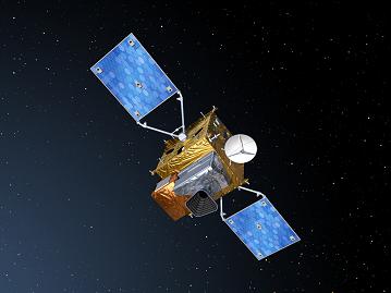
Credits: ESA – P.Carril


Sentinel-3 will determine parameters such as sea-surface topography and sea and land surface temperature. It will also determine ocean and land colour with high accuracy. The first Sentinel-3 satellite is expected to reach orbit in 2013. The spacecraft bus has a three-meter accuracy real-time orbit determination capability based on GPS and Kalman filtering.


Sentinel-4 is devoted to atmospheric monitoring and it will consist of payloads carried by Meteosat Third Generation (MTG) satellites that are planned to launch in 2017 and 2024. Sentinel-5 will be used for atmospheric monitoring as well. The payload will be carried by a post-EUMETSAT Polar System (EPS) spacecraft, planned to launch in 2020. A Sentinel-5 precursor will ensure that no data gap will exist between the Envisat missions and Sentinel-5.


You can find out more about the GMES initiative and the Sentinel missions on a dedicated page on ESA’s website.


  • Facebook
  • Google
  • Slashdot
  • Reddit
  • Live
  • TwitThis
03-5-09

HTV

Posted by


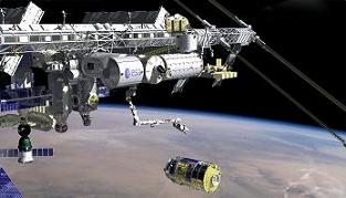
Credits: JAXA


HTV stands for H-II Transfer Vehicle. HTV is an unmanned spacecraft designed and built in Japan. HTV is designed to deliver supplies to the International Space Station (ISS).


The typical mission for HTV starts at the Tanegashima Space Center (TKSC) near Tsukuba, in Japan.


A H-IIB launch vehicle will inject the HTV on a low Earth orbit (LEO). After the separation from the H-IIB second stage, the transfer vehicle is able to navigate independently.


It will take approximately three days for HTV to reach the proximity of the ISS. During this time, it will maintain contact with the Control Center at TKSC (designated as HTV-CC) through the Tracking and Data Relay Satellite System (TDRSS). TDRSS is a network of satellites that allow a spacecraft in LEO to maintain permanent contact with the control center on the ground. HTV will use GPS to position itself at 7 km behind the ISS.


At this point, the berthing phase of the mission starts. HTV will approach the ISS within 500 m and use the Rendezvous Sensor (RVS) to move closer to the ISS. Reflectors that are installed on Kibo will allow HTV to maintain a distance of 10 m below the ISS.


Credits: JAXA


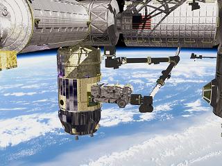
HTV does not have the capability to dock on its own to the ISS (as opposed to the European ATV), so the Canadarm2 robotic arm will be used to grab the transfer vehicle and berth it to the nadir side of the Node 2 module.


While the HTV is berthed to the ISS, supplies from the HTV’s pressurized section are transferred to the space station by the crew, and waste will be loaded from the ISS.


The cargo from the un-pressurized section will be unloaded using the robotic arm and attached either to the Exposed Facility of the Japanese Experiment Module (JEM) or the ISS Mobile Base System.


The HTV mission will end in a similar way to the European ATV: a destructive re-entry above the Pacific Ocean.


Here is some more background information about the HTV. The spacecraft is a cylinder-shaped structure 10 m long and 4.4 m in diameter. It has a total mass of 10,500 kg, of which 6,000 kg is cargo (divided into 4,500 kg pressurized cargo and 1,500 kg un-pressurized cargo). HTV can carry 6,000 kg of waste during the re-entry.


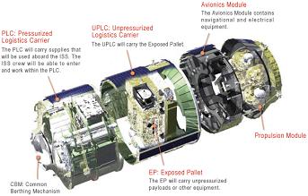
HTV consists of four modules: the Pressurized Logistics Carrier (PLC), the Unpressurized Logistics Carrier (UPLC), the Avionics Module, and the Propulsion Module. The UPLC carries the Exposed Pallet (EP), which can accommodate unpressurized payloads.


Credits: JAXA


The PLC is equipped with a Common Berthing Mechanism (CBM). This will allow the crew present on the station to enter the module in order to unload the supplies and load waste material.


The EP carried by the UPLC can be either Type I or Type III Exposed Pallets. The Type I EPs will carry payloads for the Kibo’s Exposed Facility (EF), while the Type III EPs will be used to deliver the Orbital Replacement Units (ORUs) to the ISS.


The systems in the avionics module enable HTV to execute the autonomous flight to the space station. The module also contains communication and power systems. The thirty-two thrusters installed on the propulsion module provide HTV with the capability to execute orbital adjustments and control the attitude during the mission.


HTV will add to the existing fleet of transfer vehicles that includes the Russian Soyuz and Progress spacecraft, as well as the European ATV. The first HTV mission is scheduled for late 2009.


For more information about HTV, you can visit the H-II Transfer Vehicle page on the JAXA web site.


  • Facebook
  • Google
  • Slashdot
  • Reddit
  • Live
  • TwitThis


Credits: NASA-JPL


While the preparations for ESA’s GOCE mission are under way, NASA already has its own gravity mapping mission called GRACE, which was launched in March 2002.


NASA teamed up with the German Space Agency to launch GRACE (Gravity Recovery And Climate Experiment).


GRACE currently provides detailed measurements of the Earth’s gravity field, and these measurements help scientists better understand the effects of gravity on global climate change, oceans, and land masses. This will lead to better predictions about changes in water supply, weather forecasts, and natural hazards.


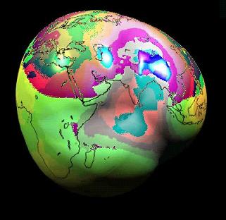
The data gathered by GRACE has been used to create the best map to date of Earth’s gravitational field. While common sense and introductory physics textbooks tell us that the weight of an object should not have different values at different locations on the surface of the Earth, measurements taken indicate that there are areas where gravity is slightly stronger or weaker than the average. Many of the peaks or valley on the maps put together by scientists can be attributed to surface features, like ridges or mountains. However, there are cases when the variations cannot be explained, and they might be related to high or low sub-surface densities.


The maps compiled from the scientific data returned by GRACE are 1,000 times more accurate then maps previously produced.


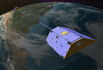
The GRACE mission consists of two satellites flying one behind another in near circular orbits at an altitude of 460 km and about 220 km apart. The satellites have really neat nicknames: Tom and Jerry. The leading satellite (that would be Jerry) sends a microwave signal to the trailing satellite (Tom) to precisely measure the distance between the two. GRACE can detect very small changes in the distance that separates the two spacecraft, down to one-tenth of the width of a human hair. The Global Positioning System (GPS) onboard Tom and Jerry is used to determine the precise location of the measurement taken.


Credits: NASA-JPL


What is the science involved in taking these measurements? When a satellite passes over an area where the gravity is stronger, it will experience a stronger gravitational pull and increase its speed. Conversely, the speed of the satellite will decrease when passing over areas with weaker gravity.


Going back to the satellites, the variations in the gravity field will cause the distance between the two spacecraft to vary slightly. On the ground, the measurements of the distance between the GRACE satellites are translated into variations of the gravity field, and this is how the maps are compiled.


GRACE maps the entire gravity field of Earth every thirty days. The snapshots allow the detection of changes in the polar ice sheets, sea level, ocean currents, the Earth’s water cycle, and even the interior structure of the Earth.


The list of applications is impressive. Measurements over ice sheets can indicate decreases in the ice sheet’s mass. Decreases in gravity can also indicate drying river basins. And not just changes in water above the ground can be measured, but also water stored in aquifers beneath the surface.


For more information about GRACE check out NASA’s web site or the dedicated web page at the University of Texas at Austin.


  • Facebook
  • Google
  • Slashdot
  • Reddit
  • Live
  • TwitThis